10 Majestic, Iconic & Odd Spots to Explore on a Death Valley Ride
Check out these don't-miss destination on an ADV Ride through Death Valley.
7. Geologists Cabin/Stripped Butte
Situated in Butte Valley at the base of Manly Peak, this famous structure and nearby landmark have a storied history. While Stripped Butte had been gawked at by countless miners dating back to the 1860’s, the cabin was built in 1930 by Asa Russell (a.k.a. Panamint Russ) after finding gold “high up the side of old Manly” (7,200’ Manly Peak).


The cabin is complete with furniture, games, stone fireplace, canned food, and an excellent view of Stripped Butte. Maintained by private groups and individuals over the years it has aged well due to their commitment and has fared much better than countless other structures of the same age in the area. A solar powered battery bank provides juice for lights enabling a touch of civility not expected this far in the backcountry.
This is a great spot to set up camp and watch the Sun’s light come over the valley onto the Butte or to take a break and imagine old Panamint Russ erecting the cabin to enjoy the same view.
8. The Amargosa Dunes (Big Dune)

Big Dune commonly referred to, as Amargosa Dunes is a formation of dunes in the Amargosa Desert. These dunes cover an area of five square miles rising nearly 500 feet from the desolate valley floor and represent the only attraction for quite a ways. Borax mining brought settlers to the Amargosa Valley at the turn of the 19th century, and people have been persevering here ever since. To put the remoteness in perspective, it’s worth noting that electricity wasn’t available for homes in the area until the 1960’s.
This is where you get to take out all your pent up aggression from not being able to ride the Eureka Dunes! It is open to all forms of motorized vehicles and is the perfect place to live out your Dakar fantasies. Amargosa’s remote location also means there’s a good chance you’ll have these dunes all to yourself.

Dispersed camping is plentiful and overnighting here is a great excuse to drop your luggage and tire pressure to carve in the sand.
9. Titus Canyon
Titus canyon is the only Point of Interest on this list that’s not actually a point; it’s a whole canyon. We felt not including Titus would be a detriment to our credibility, so an exception was made. Unlike many other places on this list, the riding through Titus Canyon is easy, but you’ll be thankful of that since the scenery is so distracting. Sheer rock faces climb as high as the eye can see and the trail eventually narrows into a slot canyon that feels like riding through a tunnel.


The road through Titus Canyon was built initially to access the ‘promising’ mining town of Leadfield that turned out to be a hoax. The town was the brainchild of a C.C. Julian who lured investors west in 1925 with false claims of a big lead ore strike. We can all be thankful for that deception though since it resulted in this fantastic road.
Motorized travel is one way, only permitted from the east (Nevada side) to west, but you can park at the west entrance of the canyon (Death Valley side) and hike in to view the slot canyon if that better suits your travel plans. Either way there is much to behold in this canyon from Native American petroglyphs to mining relics and unbelievable rock formations. Don’t skip it!
10. Rhyolite
The Queen City, Death Valley’s biggest boomtown and the largest to disappear back into obscurity: Rhyolite. On the eastern edge of Death Valley, the town was founded in conjunction with the prolific Montgomery Shoshone Mine. From 1905-1911 Rhyolite was the definition of a boomtown complete with over fifty saloons, nineteen lodging houses, eighteen stores, doctors, dentists, undertakers, and of course an opera house. It swelled from a two-person camp in January of 1905 to 2,500 before that year came to a close. When Rhyolite peaked in 1908, there were an estimated 5,000 residents.

In 1906 Charles M. Schwab purchased the mine and invested heavily in infrastructure. 1907 was the year when Rhyolite had all the markings of a modern town: electricity, plumbed water and telephone lines. Soon after though the mine’s production swooned, stocks fell and the town declined rapidly. By 1911 the mine shut down all together signaling certain death for the once promising town.


By 1916 the last train had pulled out of Rhyolite Station, power was cut off, and people were scavenging structures for building materials or moving them all together. It’s been a tourist attraction ever since and continues to draw visitors to this day. A handful of buildings remain along with abandoned relics and the Goldwell Open Air Museum which features several unusual outdoor sculptures.
Planning Your Trip
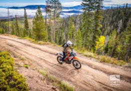
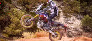
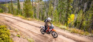
Riding Terrain: The track starts in Panamint Springs, CA which is an excellent place to begin your journey with both a restaurant and general store to fill up on supplies. You can safely park a vehicle there for $5 a day if you are trailering your bikes. The route is about 75% dirt and 25% asphalt with a total of about 500 miles (800km) of mostly rough, slow-going terrain. It will take three to four days to complete the route depending on how much time you spend at the various points of interest.

Heading out from Panamint Springs on the northwest loop, you can take the more challenging route up Lippencott Pass toward the Racetrack (counter clockwise) or run the loop in the opposite direction visiting Saline Warm Springs first. The clockwise direction will allow you to ride downhill through some of the more challenging sections of Dedekera Canyon and Lippencott. Either direction is a test of skills and be ready for deep sand around Eureka Dunes. You’ll also need a fuel range of at least 225 miles (362 km) in this remote area.
Taking the southeast loop counterclockwise out of Panamint Springs will allow you to arrive on the east side of “one-way” Titus Canyon road. But be aware there is a large rocky step up on the Echo Canyon trail that is not recommended for larger 1000cc+ adventure bikes. Even riders on smaller dual sport bikes should have advanced skills off-road to take on this challenge and make sure to have a few buddies to spot you. However, you can bypass the gnarly stuff in Echo Canyon by taking the scenic paved route out to Amorgosa Sand Dunes.
Death Valley is very remote with few gas stations or facilities, so it’s always a good idea to ride with friends and bring ample food, fuel, water, a first aid kit and an emergency GPS messaging device.
Weather: Elevations on this route range from over 6,000 feet (183 m) to below sea level, creating a variety of different temperature extremes. Spring and fall are the best times to visit Death Valley when temperatures tend to be pleasant. But even during spring and fall, temperatures can swing wildly and it can get chilly in the higher elevations at night, so be prepared. It’s possible to ride Death Valley in the winter but some of the passes may be snow covered in early spring. It is not advisable to ride Death Valley during the summer since this is one of the hottest places on earth. If rain is in the forecast, be aware of flash flooding. Many of the trails may be closed for weeks due to the rain, so always check the road conditions before you depart.
Camping/Lodging: There are several developed camping spots in and around Furnace Creek with flush toilets but these tend to attract the large tourist crowds and fill up quickly. Furnace Creek also has a 4-star historic hotel with hot springs and a gourmet restaurant if you are looking to splurge for a night. Panamint Springs has tent cabins with shower facilities and flush toilet along with a restaurant on site.

For those looking to get out into nature, there are many remote camping options. These undeveloped sites offer little more than a fire ring, and in some cases a picnic bench (e.g. Eureka Dunes), but the solitude and starry skies make it well worth roughing it. A unique option is to stay in one of the historic Death Valley cabins. Buckhorn Boxcar Cabin, Geologist’s Cabin, and Minnieta Cabin just to name a few, are available on a first come first serve basis. Just raise the flag to let others know it’s occupied and be aware of hantavirus warning signs. Hantavirus is spread when its particles are stirred into the air and breathed in. It’s important to avoid any cleaning activities that might disturb the dust. The GPX file identifies several different cabin and campground options along the route.
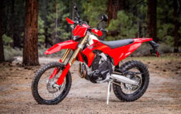
Gear We Used
During our expedition to Death Valley, we rode a variety of different terrain from deep sand to technical rocky trails and more. We had to be confident our equipment for the trip would take a pounding and keep on going. We also used a GPS navigation app on our phones to help guide us through this remote region..
Here’s a list of some of our favorite products we used during the trip:


You can read more about how these products performed during our expedition, on our Tumblr Page.
Maps and GPS Tracks
We’ve put together a route through Death Valley that will allow you to visit all of the places listed in this Ride Guide during a 4-day trip. Downloadable GPS tracks and a larger interactive map are available for free. * Note: Zip downloads don’t work with the Facebook app. Download using a regular browser such as Chrome, Safari, Edge, etc.
* Terms of Use: Should you decide to explore a route that is published on ADV Pulse, you assume the risk of any resulting injury, loss or damage suffered as a result. The route descriptions, maps and GPS tracks provided are simply a planning resource to be used as a point of inspiration in conjunction with your own due diligence. It is your responsibility to evaluate the route accuracy as well as the current condition of trails and roads, your vehicle readiness, personal fitness and local weather when independently determining whether to use or adapt any of the information provided here.
Photos by Spencer Hill and Rob Dabney
Author: Spencer Hill
“The Gear Dude” has been fueling his motorcycle addiction with adventure since first swinging his leg over a bike in 2010. Whether he’s exploring his own backyard in the Pacific Northwest or crisscrossing the United States, Spencer is always in search of scenic off-road routes, epic camping locations and the best gear possible. He began writing shortly after taking up two-wheel travel to share his experiences and offer insight with his extensive backpacking, camping and overland background.
Related Stories
Related Stories
 15 Spots You Don’t Want To Miss On A Ride Thru The Lost Sierra About an hour North of Lake Tahoe, the Sierra Nevada holds a hidden...
 14 Must-See Sites on a Ride Through California’s Eastern Sierra 9. Mono Lake Mono Lake is one of the oldest lakes in North...
 8 Great Reasons to Ride California’s Giant Sequoia Forests 5. Getting Away From It All The extensive alpine woodland of the Sequoia...
Popular Stories

KTM 690 Rally Spotted in Near-Production Form
KTM’s “Adventure” models have become one of t...
2,500-Miles In 5 Days On A KTM 390 Adventure R. Here’s How It Went
You don’t ride long distances on the highway with...
Ducati Announces Specs & Pricing Of Street-Legal 450 Enduro Model
Ducati has officially unveiled the Desmo450 EDS...
Sena Launches Their First Dual Sport Helmet
Sena is expanding its smart‑helmet lineup again...
Notify me of new posts via email
Great stuff!!! Can’t wait to do this ride!!!
Well done! Great write up and thank you for the resources to help in the planning process.
Death Valley is an awesome place. I’ve been there a half-dozen times but haven’t seen all the spots on this list (but most). I rode my Tiger 800XCA in Titus about a year ago and it wasn’t as smooth as this article suggests.. maybe it’s had maintenance since then.
I actually learned to ride sand while riding from Saline Pass Road to the Hot Springs a few years ago.. one of those “do it or go back to camp with your tail between you legs” situations… thankfully I was on a smaller bike at the time.
Dang… now I want to go back again… 🙂
BTW, if you prefer the base camp approach, consider the Panamint Springs Resort. “Resort” is kind of a loose term, but it’s a nice place. Camping spots, including full hookups for RVs, motel rooms, tent cabins, and a great restaurant with reasonable prices all things considered. No affiliation but I’ve been there each time and it’s always been great.
Very well done! Never seen anyone on big bikes hit all these tough spots before. Don’t forget to purchase a permit for your vehicle ($30 for car; $35 for motorcycle). Lots of great history of the park one can research further such as the native peoples who’ve lived there for thousands of years, the Spanish and then the geological history and processes occurring. There’s a lot of cool stories to like the Ballarat Bandit and one of a native Shoshone boy killed by an early Saline Valley settler over water rights.
Much appreciated Eric! We’ll have to look up some of those stories. Good tip about the permit too. Thanks!
I really want to do this! Wish I knew some guys that were up for it. Hesitate going by myself but might. Thanks for the info. Very Nice!
Probably not a good idea to go alone. Try posting a message on the Facebook SoCal Dual Sport group and you might be able to recruit some folks there. Good luck!
The trip was EPIC and the scenery is to die for. These places are absolutely worth the effort to see.
I did the trip alone but really wished I had someone along.
Thanks Gear dude and ADV pulse for the article and GPX files.
I’m heading out solo next week. Of course, would rather ride with a partner. But work, family…
Anything to watch out for in particular? Appreciate your recent beta.
GPX download doesn’t seem to be working, at least not for me. Page starts to open then disappears.