TransAmerica Trail Goes Virtual On Google Maps Street View
Ford and Google bring America's longest off-road trail to full 360° view.
For almost forty years, the TransAmerica Trail (TAT) — a nearly 6,000-mile network of dirt roads, forest tracks, and forgotten byways stretching from the Atlantic to the Pacific — has stood as the ultimate long-distance on/off pavement adventure route across the United States. Now, courtesy of Ford Motor Company and Google Maps, you can virtually navigate the TAT via Street View, previewing the terrain with better clarity—whether you’re gearing up for the real thing or just dreaming from afar.
The TAT didn’t exist on any map until a Mississippi motorcyclist named Sam Correro decided it should. In the mid-1980s, armed with paper atlases, stubborn curiosity and a Yamaha XT350, Correro began piecing together a coast-to-coast route that avoided pavement whenever possible. He spent decades scouting, rerouting, and recording the path, connecting legal public roads that crossed farmland, deserts, and mountain passes. His one-man mission turned into the TransAmerica Trail, which in turn became somewhat of a rite of passage for adventure riders around the world.

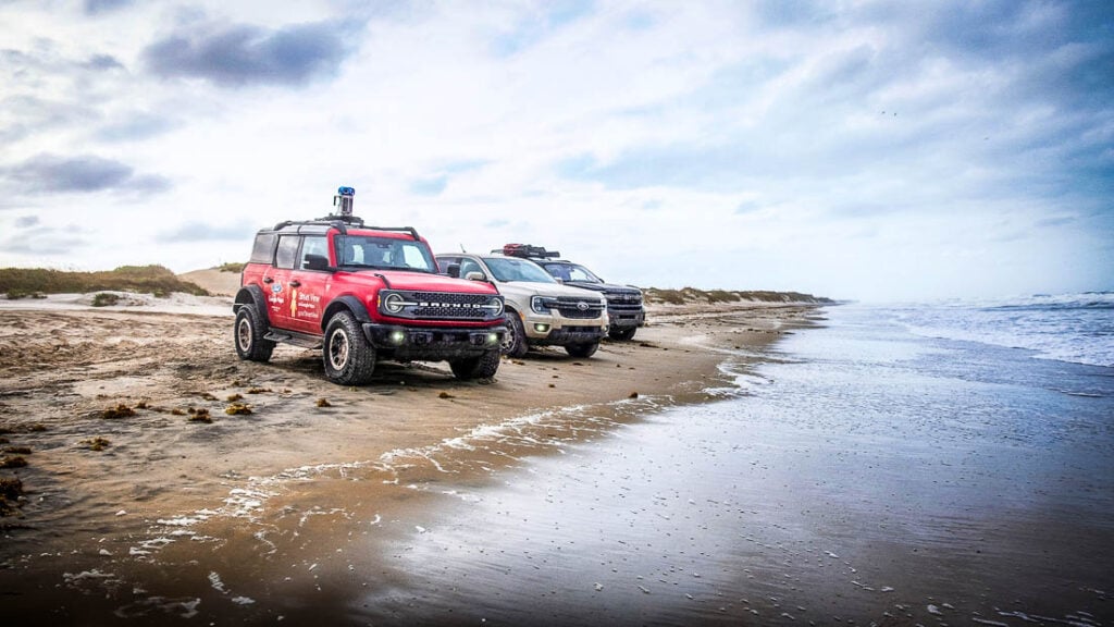
The partnership between Ford Motor Company and Google Maps marks the first time an off-road route of this scale has been virtually mapped; a project completed by a team of drivers and engineers over 32 days. Ford’s Bronco Badlands edition led the way, supported by a Ranger Lariat and an Expedition Tremor that served as the mobile base camp.
Since Google’s original Street View Trekker 360-degree camera units were designed for use on city streets and paved highways, the stock Badlands Bronco had to be outfitted with a specially modified camera system, toughened with vibration dampers, dustproof housings and reinforced mounts to survive the TAT’s rough backcountry routes.

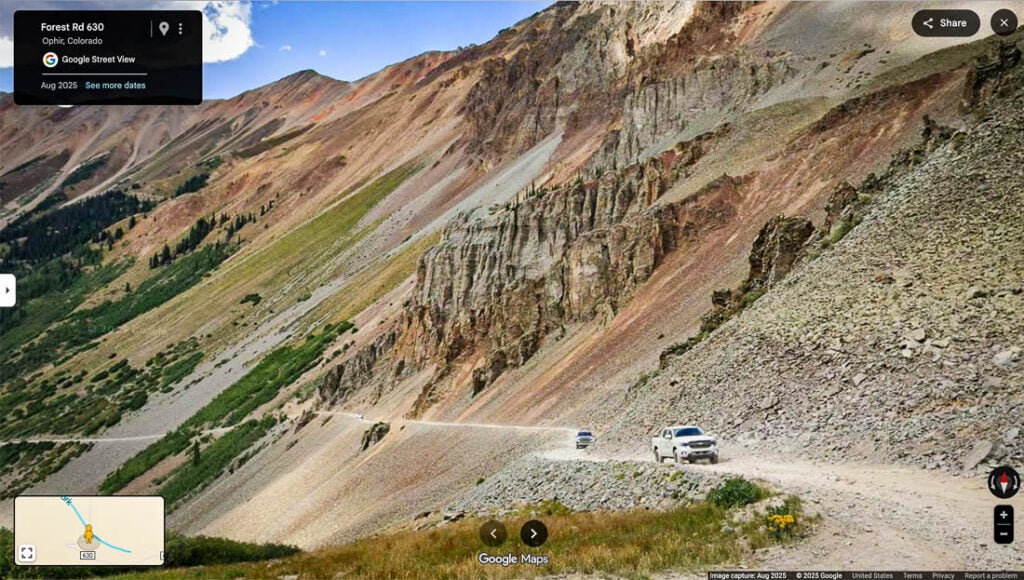
Once underway, the convoy followed Correro’s official route across 13 states and more than 5,900 miles, traversing deserts, forests, and high mountain passes—some reaching 11,700 feet in Colorado’s San Juan Range. Along the way, they captured more than half a million images, generating multiple terabytes of data. The engineers were kept especially busy, and spent long nights recalibrating hardware, stabilizing footage, and manually stitching image sequences jarred apart by the trail’s bumpy terrain, often by the scant light of their headlamps.
The team faced many of the same challenges adventure riders do. The TransAmerica Trail has never been a perfectly fixed path in the traditional sense; it’s more of a living thing that shifts with time, weather and erosion. In Oklahoma, for example, the convoy encountered a flooded section that forced a reroute, leaving an abrupt dead end in the finished Street View imagery, a snapshot of a moment on the TAT that was likely passable a few days later.

Similar detours appear where private property or impassable terrain blocked progress. Ford and Google are transparent about this: the Street View version is meant to be a visual guide, not a navigation tool, so there’s no downloadable map, and riders are encouraged to rely on the official roll charts and GPS files found at Correro’s original website when heading out on the physical trail.
What the team did achieve, however, is valuable. Now, for the first time, you can virtually trace Correro’s legendary route on Google Maps’ Street View. The simplest way to do it is using the mobile version, where you can follow a continuous green ribbon across the landscape. Simply open the app, search for “TransAmerica Trail,” select “Street View” from layers, zoom into any area on the green line that marks the path across the country, then tap the line to drop in and explore.

Unfortunately on the desktop version of Google Maps, you can’t see the entire route going across the country. You’ll need to search for known roads or waypoints on the official TAT, then drop into Street View at those exact spots where you can preview sections you plan to ride.
With this new feature, you can click your way through Tennessee’s hardwood forests, across the Ozarks of Arkansas, over Oklahoma’s red-clay flats and onto the snow-dusted passes of Colorado like Ophir, Cinnamon, and Engineer. You can scroll through the high desert of Nevada, the misty mountain roads of Oregon, and end at the Pacific Ocean in Port Orford, where many riders finish their journey with boots in the surf.
Ford describes the undertaking as part of its From the Road storytelling initiative, which celebrates real journeys and the people who take them. For the Bronco, the TAT served as both subject and proving ground. “This wasn’t about promotion,” said one project manager. “It was about showing what’s still out there to explore.” That spirit is echoed in Google’s own motivation to expand Street View beyond pavement and create a record of the country’s most remote and beautiful places.
“Along the way, we camped, stayed at motels, cooked meals on the side of the road, and ate at charming small-town restaurants, all while following Tread Lightly! principles,” reads the story on Ford’s website. They also endured searing desert heat, surprise mountain snow, and the kind of fatigue that comes from hundreds of miles of washboard roads.
In a way, their experience mirrored the one Correro designed for riders: physically demanding, unpredictable, yet profoundly rewarding. In another section of the From the Road account, it’s noted that those involved “went from a group of mostly strangers to a little temporary family,” which sounds exactly like what most of us experience on any given two-wheeled adventure.
For motorcyclists, the imagery opens new possibilities. You can zoom in on a washed-out Oklahoma road to decide whether a detour’s needed, preview a steep Colorado climb, or check if a Utah wash looks like hardpack or sand. It’s no substitute for firsthand experience, but it’s a more-comprehensive planning tool for riding the TAT unlike anything that’s come before.

Among the off-roading community, however, reactions to the project have been mixed. Some see it as a gift — a way to preserve and share our country’s beloved TAT. Others worry that increased visibility could bring unwanted traffic to sensitive areas. Both perspectives are valid. The TAT’s survival does depend on responsible travelers and a shared respect for the land, but even those wary of overexposure acknowledge that this project immortalizes something that could one day disappear.
Correro’s original goal when he set out to map the TAT was simple. He wanted to show people the “real” America: the small towns, the forgotten roads and all the wild, empty spaces in between. Nearly forty years later, Ford and Google have found a way to bottle that vision within a movable snapshot that will live on indefinitely.
You’ll find exploring the route is a lot more intuitive on the mobile app, where you can follow the line across the country and jump in anywhere. And as previously mentioned, on Desktop you’ll need to search for known locations on the route. Reliable entry points we’ve found include EW 4 Rd Turpin, OK; Ophir Pass, CO; Turkey Hollow, AR; Barklow Mountain Northeast Trailhead, OR; and Emigrant Pass Rd, UT. And of course for official route maps and GPS navigation resources, visit transamtrail.com. Once you have the tracks, you can choose any waypoint along the route and search for the GPS coordinate in Google Maps to get a 360-degree view.
Photos by Ford and Jenny Morgan
Author: Jamie Elvidge
Jamie has been a motorcycle journalist for more than 30 years, testing the entire range of bikes for the major print magazines and specializing in adventure-travel related stories. To date she’s written and supplied photography for articles describing what it’s like to ride in all 50 states and 43 foreign countries, receiving two Lowell Thomas Society of American Travel Writer’s Awards along the way. Her most-challenging adventure yet has been riding in the 2018 GS Trophy in Mongolia as Team AusAmerica’s embedded journalist.Related Stories
Related Stories
 Mobile GPS App REVER Launches LiveRIDE Location Sharing Features REVER – the motorcycle ride planning, GPS navigation and tracking app – continues...
 Trail Tech Launches New Voyager Pro4 Off-Road GPS System Trail Tech has released their new Voyager Pro4, an update to its off‑road...
 Garmin Debuts ‘Zumo XT3’ With New Ride-Data Tools & 2 Screen Sizes Garmin has rolled out the zūmo XT3, the next step in its motorcycle‑focused...
Popular Stories

KTM 690 Rally Spotted in Near-Production Form
KTM’s “Adventure” models have become one of t...

2,500-Miles In 5 Days On A KTM 390 Adventure R. Here’s How It Went
You don’t ride long distances on the highway with...

Ducati Announces Specs & Pricing Of Street-Legal 450 Enduro Model
Ducati has officially unveiled the Desmo450 EDS...

Yamaha Launches First‑Ever Ténéré Trek Adventure Rider Rally
This summer, Yamaha is bringing its BLU CRU commu...


Notify me of new posts via email
Groovy!