A Moto Expedition To The Fabled Lost Coast
Discovering the rugged allure of California's least-traveled coastline.

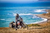
In Northern California, a four-hour drive from San Francisco, there lies a stretch of coastline lost to the elements. With terrain far too hostile for painting ribbons of tarmac, waves smash themselves into oblivion, with no souls nearby to bear them witness.

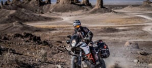
We would begin the task of taming the stunning shoreline amidst the mythical forests of the fabled Lost Coast at the end of summer. While the area hadn’t seen rain for months, it was just our luck that a major weather system coincided with our journey. We prepared for a wet and slippery ride as a result. ADV Pulse Senior Editor Rob Dabney and I were astride two Royal Enfield Himalayans while our photographer, Sam Bendall, chose a draft horse to accompany these two burros — a Triumph Tiger 800 XCA. Next to the Tiger, the Himalayan lacks some of the creature comforts and power of the larger, more touring-oriented Triumph. Yet where it lacks bells and whistles, the utilitarian Royal Enfield makes up for it with its maneuverability in tough terrain.
We embarked on our journey in the early hours of the morning near the town of Willits, California, riding into the forests on a beautiful twisty backroad, carving through a mix of woods and farmland. The surrounding area marks the start of Mendocino’s vast redwood forests and makes an ideal place to begin your trip if you intend to experience the redwoods in a pristine setting.


With just a light mist hitting the visor, I indulged in a false hope that perhaps we might get lucky with the weather. From here, all that separated us from the coastal town of Fort Bragg was a 40-minute jaunt on what we thought would be a smooth dirt track named Sherwood Road. This stretch promised to be tame and scenic, filled with dense redwood groves and the sort of environment that leaves one expecting an Ewok around each corner. Instead, we were met with signs that this adventure may have been cursed before it began. Timed perfectly with our emergence onto the dirt, light rainfall turned into more of a deluge, and we quickly found that this road becomes a quagmire when wet.


Over the next 24 miles, our machines clawed away at the clay-enriched soil even when our own boots could find no traction. Times like these often reveal the best or worst in people, though we instead found a tight camaraderie with a hint of ribbing to keep the mood light. To help distract us from the exhaustion, we started an impromptu game of HORSE, marking each time we had to force our machines back onto two wheels with a letter spelling out the word. By the end of this grueling stretch, we found ourselves having to get creative in extending the game beyond five letters, which provided comic relief throughout the weekend.

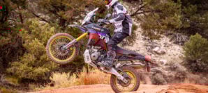
One thing became abundantly clear though; the Himalayan was the superior machine for these conditions. Where Rob and I were able to tractor up and down hill after hill with relative ease, Sam might as well have been on a slip and slide with his heavier machine. Getting the big beast uprighted in this muddy mess also required two people.

It took us three hours to reach Fort Bragg and along the way, Rob ‘annoyingly’ managed to keep his Himalayan upright for the duration, a statistic I failed to match and one that Sam seemingly forgot about entirely as he quickly surpassed “H-O-R-S-E.” As the trail continued on mercilessly, we had a newfound appreciation for our machines. The skies furiously pounded us while the grounds attempted to swallow our tires whole, yet here we were — soaked, tired, but still making progress. We rode into town battling fogged-up visors, hungry and exhausted from the constant melee, seeking a bite to eat. By this point, moisture had gotten into everything. The bar-mounted iPhone we were using for GPS navigation shut itself off and we could no longer document the trip because our camera lenses were totally fogged.


We happened upon a deli in town and across the street was a laundromat. The decision was made to wait out the storm a bit and see if the rain would relent while we dried some gear and filled up on hot coffee and sandwiches. As 5 o’clock rolled around, there was still no relief from the rain and we had more slippery tracks ahead of us to reach camp. The idea of setting up tents in the dark while raining didn’t seem too appealing after just getting all our gear dried out. We decided to grab a hotel for the night in hopes that Saturday morning would grant us more favorable weather.
Fresh dawn greeted us with low slung clouds, thick fog, and unfortunately more rain. We suited up, thankfully in dry gear, taking doses of hot coffee before tending to the needs of our trusty partners in battle. A splash of fuel and a few tweaks to our machines to correct the scars of Friday’s drop fest saw us off on our way to Glass Beach. This relatively small point of interest is situated on the teetering edge of Fort Bragg where the entire town once funneled its filth onto the beaches. The sight is a strange one. When you clamber down the cliffs to where the waves pulverize the rocks, the remains of the old garbage heap are there to greet you — countless shards of colorful glass smoothly shaped by the water’s turbulence.The irony of the many posted signs asking that visitors leave no trace and take with them none of the historic remnants of garbage was not lost on us at this slightly bizarre attraction.


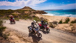
We saddled up, preparing to ride the next 30 miles of Highway 1 where it links up with Usal Road. The strong smell of eucalyptus and various conifers overwhelmed the air as the wet, knotted pavement quickly passed below our tires. A brief stop at Blues Beach provided our first chance to get our tires a taste of sand. Unlike most beaches along the California Coast, vehicles are not barred from this one. After a quick rip around the beach, we soon learned our 25-horsepower Himalayans, loaded with camping gear, aren’t all that graceful in deep sand.


Back on solid ground, we stopped to check our GPS location on the beach access road when an SUV came up behind us. As I backed up slowly to make room for the vehicle to pass, it suddenly felt like something was pulling on my rear wheel. Before I knew it, I was sliding backward with brakes locked and front tire clawing at the ground. Somehow, I hadn’t noticed the cliff behind me I had rolled off and now I was falling for what felt like an eternity, staring up at the sky, not knowing when my fall would stop or what I might land on.
Regrettably, for me, this brief jaunt to the beach ended with yours truly 15 feet down in a drainage ditch. Falling backward over a ledge is not a feeling I’m at all familiar with, nor is it a situation I gather my cohorts are accustomed to witnessing, made apparent by the widening of their eyes. Once reality had set in for all involved and after a damage assessment revealed nothing wrong with me, apart from being stuck between the bike and a culvert, Sam quickly jumped down to help free me. Luckily, I wasn’t hurt, other than being a bit dazed, but the blow to my ego would definitely leave a mark.

Although relieved that I was uninjured, the potential damage to my motorcycle, as well as the time it would take to recover it, seemed likely to all but end our aspirations of completing the rest of the trip up the Lost Coast — but as is often the case, things are not always as they seem. The young lady — whose path I was trying to clear when I tumbled over the ledge — offered to use her Range Rover as a recovery vehicle. After a bit of ingenuity with tow straps and tie-downs not at all designed for hauling a motorcycle up a near-vertical slope, we managed to get the mighty Himalayan out of dire straits in roughly 20 minutes. Besides this small victory, we also found that the only damage suffered was a slightly tweaked gear selector that easily bent back into shape, and a scratch on the oil cooler guard. Even better, the rain had now halted, and the skies were starting to clear. The curse had been broken! Or so we hoped.

Once moving again, we found ourselves turning away from the cliffs and toward a metropolis of new growth redwood. This marked the final stretches of the Pacific Coast Highway — where road crews once decided to abandon their efforts and turn further inland away from the unwelcoming cliffs above the Pacific. A quick pass through Rockport led us to the starting point of Usal Road. Given the events of the last two days and the fact that we’d all heard numerous reports of Usal being savage when wet, we approached this next segment cautiously. What occurred next surprised us all.


Usal Road and the accompanying creek are named for the USA Lumber company that operated a mill here from 1889 until 1902 when the operation was wiped out by fire. Some structures remained where revelers gather on Usal Beach until the few remnants also burned in 1969. The road was anything but the savage beast it had been hyped up to be, despite being waterlogged from the prior day’s drenching. Our bikes easily found traction as we began snaking up this truly stunning road to Usal Beach. Winding through these woodlands offers more photo ops than you can shake a stick at. As we rose higher into dense forests of Sequoia Sempervirens, a thick canopy soon gave way to reveal we were on a cliff overlooking the beach. A few turns navigating a steep descent later and we were riding through a grove of Coastal Aspens where the sand meets the crashing waves of the Pacific.


Once there, it became quickly apparent that Usal Beach caters more toward partygoers. Not the sort of tranquil place an adventurer seeking the remote spaces of solitude might wish to set up camp. Yet amongst the litter and unregulated mayhem, one can still find brief stretches of tranquility — and so we found our slice of quiet to break for lunch, but not before following our fearless leader Rob through the sand to a spot offering 360° views of the coastline. There we enjoyed a feast of beef jerky, Vienna sausages, and energy bars.

Back on track, the dirt road we had found moderately trafficked was now largely untouched. It was obvious that most travelers never continue further than Usal Beach, a discovery we were thrilled to possess as we enjoyed the glorious shafts of sunlight slipping through the canopy above to the forest floor below. We had been told various stories of how difficult Usal Road can become once beyond the beach — tales of baby head rocks, ledges, and numerous other obstacles left us apprehensive. The miles rolled on though and apart from a few small sections where the road wasn’t what dreams are made of, those earlier concerns rapidly diminished as the track revealed itself to be a perfect stream of flowing terrain.


It would have been easy to continue from here into Shelter Cove on asphalt, but we opted for a more complete journey down Briceland Road. This 7-mile round trip became a highlight of our day with its picturesque forests, exposed cliffs, and dramatic cloud cover that had again found us. We reached the Needle Rock Visitor Center area in awe of the foggy coastline and majestic seaside cliffs. Our tranquility was broken only by a voice over the intercom excitedly pointing out a massive bull elk grazing just off the side of the road. Naively, our photographer and I cautiously waded into the tall grasses for a closer inspection, keenly aware that this elegant creature could quickly end our trip or worse.


Afterwards, we found ourselves talking to the camp hosts and contemplating a stay for the evening among all that is wild. That same bull elk sauntered within a few feet of us with a look in his eye that made it clear we had better make way. We backed off slowly and decided we’d had enough close contact with nature. With a few hours of daylight left and the prospect of burgers and beer in the next town calling us, we packed up and headed north towards the only real stretch of civilization on the Lost Coast, Shelter Cove.


In town, we rode down to the boat launch at Cove Beach where a large group of locals had gathered to socialize, surf and tip back a few beers. A short visit ended mostly uneventfully, apart from the algae-covered concrete on the water’s edge causing our leader to have his first drop of the trip, earning himself a letter H. We relished in the moment and then concluded our day at Gyppo’s Ale Mill. With an incredibly satisfying meal in our bellies and camping options closed for the night, we decided to stay at the nearby Lost Coast Inn where we wound down the evening, savoring liquid spirits and conversation with the sound of waves dominating the atmospheric musical score.


Our adventure continued into its final day as the rising sun gradually lit up the azul abyss of a bathtub that is the Pacific, and with it unblemished views up the coast as far as the eyes could muster. After a humble breakfast and spending probably too much time watching the ocean’s efforts at eroding the continent, we packed our things and set off with our sights set on the King Range National Conservation Area, which delightfully began with a dirt road straight out of Shelter Cove.


Once home to the Mattole and Sinkyone peoples, King Range is a vast area now protected and managed by the BLM (Bureau of Land Management). Like much of the North Coast, it was logged heavily in the 1800s and early 1900s, though conservation efforts over the last century have helped it bounce back significantly. The range encompasses the entirety of the aptly named “Lost Coast” and with good reason. Rugged terrain whose elevation changes constantly and overgrown tracks are the sort of thing the Royal Enfield Himalayan was made for. Without effort, our machines chugged up and down the loose, steep grades — the technicality of which only increased once we turned toward King Peak.

A few turns later and we found ourselves gifted with yet another incredible view of the Pacific. The three of us took a breather and relished the moment briefly before climbing even further over the unending route of scree and loose rock. Here, the forest engulfs all that enters, allowing only thin beams of light to seep through. With King Range slowly fading in our mirrors, a lasting impression was made on each of us of this remarkable place where redwood forests and mountains meet the sublime beaches of the Lost Coast.


We wound down Wilder Ridge Road, a stretch of pavement that can’t make up its mind as to whether it should be paved or not, then found ourselves straddling the Mattole River. The small village of Honeydew and its solitary general store served as a quaint spot for a quick bite before continuing to Mattole Road. Closer to Mattole beach, we spotted something out of place in the periphery obscured by the Douglas firs that line the road. As we circled back to see if our eyes had deceived us, we discovered an old Ford F-150 pickup suspended in a tree. The scene of this battered truck hanging high above the forest floor could easily be mistaken for something in a horror movie, though with the mid-afternoon sunlight breaching the canopy — our visit was nothing if not strangely peaceful.


Once we had our fill of this bizarre local attraction, we rode a short way further to where the Mattole River meets the beach at Prosper Ridge Road. For us, this provided one last opportunity to ride atop the cliffs via an unpaved section of road to Punta Gorda. Perched nearly a thousand feet above the ocean, we reverted to a state of childlike joy as we played in the massive winds that, despite their best efforts, failed to carry us down to the rocks below.


With time fading, we saddled up one last time to ride out the same way that brought us in. The numerous whoops and humps on the steep climb out provided ample opportunities to air out our two-wheeled companions.


There was still more to see continuing on north through Petrolia along Mattole Road — a stretch of pavement that skirts the beaches for seven miles before pointing back inland to Ferndale, marking the official end of the Lost Coast. For us however, time had run thin with the various setbacks encountered and the decision was made to exit back through Honeydew. That meant a couple dozen more miles of incredibly scenic and twisty asphalt. As beautiful as it was, the route only improved as we found ourselves thrust right into the center of Humboldt Redwoods State Park. We lacked time for much exploration but it would have been a massive waste not to at least stop to enjoy a few minutes amongst these ancient giants.

The remainder of our trip would take us back south toward Willits where our journey began, on what may be the most scenic section of California’s Highway 101. This final stretch allowed for time to reminisce about the amazing trip that was soon ending. Nature had launched its worst at us, and even when we faltered, our budget-friendly machines pressed on. Slogging through the muck in the misty forests only added to the mystery of the experience. And when the sun finally broke through on the coast, it was an even more dramatic reveal of its beauty. In the end, the Lost Coast lived up to all of its promise of adventure… and then some.
Maps and GPS Tracks
Want to do this ride? Detailed GPX tracks and an interactive map are available for download free.*
* Terms of Use: Should you decide to explore a route that is published on ADV Pulse, you assume the risk of any resulting injury, loss or damage suffered as a result. The route descriptions, maps and GPS tracks provided are simply a planning resource to be used as a point of inspiration in conjunction with your own due diligence. It is your responsibility to evaluate the route accuracy as well as the current condition of trails and roads, your vehicle readiness, personal fitness and local weather when independently determining whether to use or adapt any of the information provided here.
Photography by Sam Bendall, Ken Morse & Rob Dabney
Author: Ken Morse
While Ken’s two-wheeled exploits began only a few years ago, he’s no stranger to adventure. Since 2006, he’s been wandering all over the U.S. in various four-wheel drive toys, exploring as much hidden terrain in the backcountry as possible. Having straddled his first motorcycle in 2019, he quickly became obsessed and made the switch to two wheels. Now he spends most of his free time riding, wrenching and traveling on adventure motorcycles from his base in California’s Sierra Nevada Mountain Range.Related Stories
Related Stories
 Lost Coast BDR-X Brings New Coastal Adventure Loop To California Backcountry Discovery Routes (BDR) has announced the launch of its latest project, the...
 Royal Enfield Himalayan 650cc Twin Spied In Near Production Form Rumors have been swirling around for years about a super-sized Royal Enfield Himalayan...
 Royal Enfield Unveils Next-Gen Scram 440 Model A new Scram 440 was unveiled at Motoverse 2024, Royal Enfield’s largest annual...
Popular Stories
Sena Launches Their First Dual Sport Helmet
Sena is expanding its smart‑helmet lineup again...
Ducati Announces Specs & Pricing Of Street-Legal 450 Enduro Model
Ducati has officially unveiled the Desmo450 EDS...
Honda Debuts Adventure Motorcycle Film On Streaming Platforms
Honda is bringing its flagship adventure‑tourin...

Classic Meets Modern Rally In This Dialed Honda XR600R Build
For many riders, the XR600R needs no introducti...
Notify me of new posts via email
Thank you for this wonderful travelog ! .
I’m not a good rider on soft / muddy roads so I may never get to see this but it’s great, reminds me of the monthly “Way 2 Go” column in the Free 2 Wheel magazine I read before there were computers .
-Nate
Nothing better than becoming a horse with friends!
Nice! Hopefully all those sweet dirt road choices came from Butler Maps G1 California map. I helped create all of that. The Lost Coast is one of the best ADV riding areas in the US!
I dislocated my shoulder on Usail Road a few years ago. It was dusty and my front tire washed out. I still ride.
I live in Shelter Cove and have ridden hear for years and started a club called the “Cove Rats” We would do this ride once or twice a year in the other direction headed to Upper Lake in Mendo You guys got to see the real “Lost Coast”
My wife and I camped at Usal beach in 1996. We had ridden from Vancouver Canada to San Francisco and were on our way home. We met a hippie in Petaluma who told us the way to Usal. We were on a GS750EF and a CBX550F. Bungie cords, jeans and work boots. In the days before $1000 jackets and GPS. Thanks for bringing back some good memories. Now I feel old 🙂
It would nice if you guys would post a gpx file or map of these routes so we could check them out.
I agree.
I use the BLM King Range Conservation Area maps GPS goes to sh*t out here we say GPS= Gets pretty stuck
@Tom GPS tracks have been added. Cheers!
Killer trip and great photos. Definitely inspired to take my Himalayan there someday. Amazing. Thanks for sharing.
Thanks for this. We’re doing this on Nov 19th/20th. Forecast predicts rain should be a sloppy good time!
Thanks for posting this report and the gpx files – helped me plan a trip up there over Labor Day weekend and very grateful for having your route as guidance and inspiration.
Fantastic trip. I skipped the Sherwood Road (time pressure and a long day falling over on Cow Mountain the day before) but followed most of the rest. Saddle Mountain Road was an interesting challenge but the rest was just great riding and incredible scenery.
Thanks again – will be watching out for the next one!
Daniel.