8 Great Reasons to Ride Washington’s Olympic Peninsula
Explore ancient forests, glacial peaks and roaring falls of the great North West.
6. Scenic Backroads
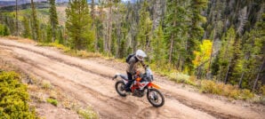
The Highway 101 loop around the Olympic Peninsula is considered one of America’s most scenic drives, and our route utilizes that renowned asphalt whenever equally spectacular dirt isn’t available. If that wasn’t epic enough, we put together a similarly stunning route that parallels this renowned asphalt in many places, offering more fabulous views or better twisties when possible.


The Peninsula is home to many peg scraping worthy forest service roads that take you through deep sections of dense forest and leave you wondering why they dedicated the time and resources to pave such remote stretches. This will only be a fleeting memory, though, as you lean hard into the next corner and take in the epic view. It’s rare to see regular traffic on many of these isolated roads, but always be aware of the possibility. The stretches of twisty road along Lake Crescent and Lake Quinault are particularly scenic and not to be skipped.
7. Idyllic Camping
Dry camping and established campgrounds with services are plentiful on the Olympic Peninsula, as well as in the National Park. All of the campgrounds within the park’s boundaries are first come first served, except for the wildly popular Kalaloch and Sol Duc sites along the coast. Fear not, there is certainly no shortage of scenic camping anywhere on the peninsula!


Truth be told, some of the best spots are tucked away far from the large park run operations or private RV parks. If you don’t mind forgoing flush toilets and running water, then your options are nearly limitless. Primitive or dispersed camping is excellent for avoiding crowds and embracing the solitude that this region has to offer. Look for already established sites with fire rings or clearings, typically screened from roads and trails, and at least 200 feet from water. Some of the best examples of these sites can be found on the west side of the peninsula and feature fantastic views of the Pacific with no light pollution and no neighbors.
8. Historic Sights

The Olympic Peninsula has a rich past that played an essential part in the Pacific Northwest’s heritage. It was one of the last unexplored places in the contiguous United States and turned out to be culturally significant and wealthy with natural resources.
The park was initially known as the Olympic Forest Reserve established in 1897 by President Grover Cleveland, which is telling that officials saw the need to preserve this resource fertile land in a time when industry was king. Then in 1909, President Teddy Roosevelt took additional steps to protect the area by designating part of the reserve as Mount Olympus National Monument. Finally in 1937, after a visit to the area the previous year, President Franklin Roosevelt signed the act designating Olympic National Park.


A few of the National Parks gems include Quinault Lodge, Sol Duc Hot Springs, and Lake Crescent Lodge. The Quinault Lodge was built in 1926 and styled after Old Faithful Inn in Yellowstone and Sun Valley Lodge in Idaho. Locals had been gathering on the shores of Lake Quinault since the 1880s before a fire claimed the site’s original log cabin structure that preceded the structure erected in the 1920s still in use today. Franklin Roosevelt stayed there nine months before signing the act designating Olympic National Park.
Similarly, Sol Duc Hot Springs is another place where people have been gathering since the 1880s except explicitly for the springs healing qualities. It was once the site of a 164-room, 5-star hotel, and resort that was unfortunately destroyed by a fire in 1916. Another gem is the Lake Crescent Lodge, originally opened in 1915 as Singer’s Tavern with just five rooms. FDR also stayed here on his 1937 “fact-finding” visit to the peninsula, prompting the owner to name lakeside cabins after him in the following decade.


During WWII, military installments at Fort Flagler, Fort Warden, and Fort Casey were utilized to establish the “Triangle of Fire.” These were crucial coastal defense pieces during the war and are now state parks accessible to the public. Many military installments from this area dot the peninsula and can be fun to explore, such as Camp Hayden highlighted in our tracks.
Planning Your Trip
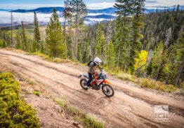
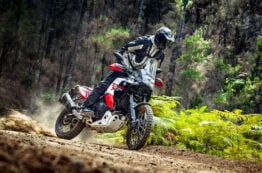
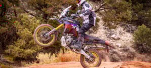
Riding Terrain: By and large, most of the off-road riding on the Olympic Peninsula is more scenic than it is technical. The loop we’ve laid out is perfect for those with large displacement adventure bikes looking to get dirty, with enough challenging sections and obstacles to keep smaller dual sport riders entertained. The section east of Lake Quinault probably offers the most challenging riding, while segments near Hurricane Ridge and along the coast are arguably the most visually stunning.

The route is roughly 30% asphalt and 70% dirt with a total of about 650 miles. Fuel is not a significant concern with filling stations in Hoodsport, Brinnon, Quilcene, Blyn, Sequim, Port Angeles, Forks, Queets, and Quinault along the route. The longest off-road stretch is between Quinault and Hoodsport, but as long as you have close to a 100-mile range, it should be no problem.
Weather: Some areas of the Olympic Peninsula have an annual rainfall of up to 170 inches, that’s just over 14 feet! So, rain is something to consider even during the height of summer. It’s best to pack your rain fly and waterproof riding layer no matter what the forecast might say. The temperatures, on the other hand, are nearly perfect for adventures, rarely dipping into the ’30s and hardly ever cresting into the ’80s. Early spring through late fall is when you want to go with the only considerations other than rain being snow at higher elevations (Winter) and forest fires that have increased in recent years (Late Summer).

Camping/Lodging: The Olympic Peninsula is ripe with amazing places to stay, whether you are looking to rough camp or experience what the park’s historic lodges have to offer. Some of our favorite camping locations include Kalaloch Campground on the coast, Heart O’ The Hills Campground near Hurricane Ridge, and Dosewallips Campground on the sound. For those seeking more solitude, dispersed camping can be found nearly anywhere on the peninsula, but some of the most scenic spots are south of Forks on the coast and above Lake Cushman near the southeast corner of our loop.
Our favorite accommodations with turndown service include the Lake Crescent Lodge, Lake Quinault Lodge, and Kalaloch Cabins. These are all picturesque digs steeped in historical value and brimming with character. More mainstream motels and chain hotels are available in all the sizable towns as well. With any of these options (except dispersed camping), reservations are recommended.
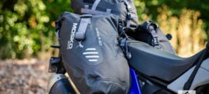
Gear We Used

During our expedition through Washington’s Olympic Peninsula, we rode a variety of different terrain and weather conditions. We chose equipment for the trip we could feel confident would keep both our bikes and bodies protected..
Here’s a list of some of our favorite products we used during the trip:


You can read more about how these products performed during our expedition, on our Tumblr Page.
Maps and GPS Tracks
We’ve put together a route through the Olympic Peninsula that will allow you to visit all the places mentioned in this Ride Guide and more during a 4- to 5-day trip. Detailed GPX tracks and a larger interactive map are available for download free.*
* Terms of Use: Should you decide to explore a route that is published on ADV Pulse, you assume the risk of any resulting injury, loss or damage suffered as a result. The route descriptions, maps and GPS tracks provided are simply a planning resource to be used as a point of inspiration in conjunction with your own due diligence. It is your responsibility to evaluate the route accuracy as well as the current condition of trails and roads, your vehicle readiness, personal fitness and local weather when independently determining whether to use or adapt any of the information provided here.
Photos by Spencer Hill
Author: Spencer Hill
“The Gear Dude” has been fueling his motorcycle addiction with adventure since first swinging his leg over a bike in 2010. Whether he’s exploring his own backyard in the Pacific Northwest or crisscrossing the United States, Spencer is always in search of scenic off-road routes, epic camping locations and the best gear possible. He began writing shortly after taking up two-wheel travel to share his experiences and offer insight with his extensive backpacking, camping and overland background.Related Stories
Related Stories
 5 Must-Do Adventure Motorcycle Rides in Moab Moab, Utah is known as the Mecca of off-road recreation with seemingly endless...
 12 Unforgettable Spots to Explore on a Southwest Utah Ride 6. Grosvenor Arch. Grosvenor Arch is a unique masterpiece of nature. Just off...
 10 Majestic, Iconic & Odd Spots to Explore on a Death Valley Ride 7. Geologists Cabin/Stripped Butte Situated in Butte Valley at the base of Manly...
Popular Stories
KTM 690 Rally Spotted in Near-Production Form
KTM’s “Adventure” models have become one of t...
2,500-Miles In 5 Days On A KTM 390 Adventure R. Here’s How It Went
You don’t ride long distances on the highway with...
Ducati Announces Specs & Pricing Of Street-Legal 450 Enduro Model
Ducati has officially unveiled the Desmo450 EDS...
Yamaha Launches First‑Ever Ténéré Trek Adventure Rider Rally
This summer, Yamaha is bringing its BLU CRU commu...
Notify me of new posts via email
Nice write up! Look sweet……and to someone who’s new to WA…..PERFECT!
Roads not worth it. Views not worth it. Weather not worth it. Locals politically minded and not friendly. Heavily regulated and patrolled. High fines. Go somewhere else.
Don’t do anything illegal, and you don’t have to worry about getting fined…
It sounds like you might have a bias or alternative motives, though.
I’ve been riding the Olympic Peninsula for going on 13 years now. It’s my favorite riding area. I’ve never had one single lick of problems with anyone or any regulation.
You forgot to say, “Stay off my lawn!” 🙂
I call BS on your review. I see that your post is from January 2020 so pre COVID. I can’t imagine what “Patrols and Regulations” you could be referring to? Rain in January, well yea, you did realize where you were going and the climate of the area for that time of year, right? All of the local people were friendly and kind to me so again, I’m stumped by your comments. I’ll return to this route time and again ow. It was a great experience.
Typical Trump voter.
I added this to my Gaia GPS, and made it public: https://www.gaiagps.com/public/ODSZlxqxS7ugpkAoavs6lBiv
Great article! Some of the best riding I’ve ever experienced. Can’t wait to go back!
The antiquated image of loud dirt bikes with careless operators is comical in this instance. We’re talking about modern motorcycles designed for road use, piloted by riders that have the means to own and maintain them. If I were you I would be more worried about the small army of transients and drug addicts that loiter in these areas, not to mention the hordes of beer drinking gun toting weekend worriers that leave behind unimaginable quantities of trash.
Regardless they tear up the terrain and like I said you better bring a chain saw and hope they are light enough to carry out. My sister lived in the area a month and a tree fell on her car.
Your basing your comments on your sisters one month experience? Trees fall in the PNW. As for motorcycles tearing up terrain, on logging roads? you have seen what mother natures erosion does, right? look at mother natures erosion on hiking trails. Motorcycles aren’t contributing to that at all.
So here’s a question – where is the nearest major civilisation ………..that would allow for hire of an adventure bike ?
Rob at Northwest Adventure Ride rents KLRs with luggage. A friend and I did this ride over the summer of 2019 on his bikes, and we had a blast.
Thank you for this article.
Great report Spencer! We’ve ridden all paved up there but always wAnted to do a more backcountry route. Nice to see you riding KTM now. I have always wondered what you have been up to so i’m glad to see this. Cheers my fellow shipmate! ERIC
While the riding season out here won’t be happening for a few months, Route 5 from Hoodsport to Quilcene still has part of it closed. FS 2441 from the intersection of FS 2464 to FS 2480, and the 2480 to FS 25 (Hamma Hamma road) are still closed due to the 2018 Maple Fire. The FS road closure document said it was to be closed until 30 OCT 18, yet it is still closed – confirmed that on a Xmas tree cutting trip up there in mid-December.
Hopefully, they will be opened up again this spring – call and let them know, and ask them to get the washout fixed on FS 2510 – IMO, one of the best sections on Route 5 – before the washout blocked it!
ONF Road conditions – https://www.fs.usda.gov/detail/olympic/alerts-notices/?cid=stelprdb5293706
This is an excellent write up Spencer! Thank you for this. I have been planning a trip here for summer ’20 and have been piecing things together through other sites. This article gives me all the info I needed, very much appreciated. I’m surprised to see negative comments on this.
Excellent article and some absolutely Beautiful pics! This is what I’m looking for as I move from dirt bike racing into a little slower pace as well as taking the time to smell the roses. I learned years ago that Adventure riding is just that,…..An Adventure. You have to be ready for anything.
Thanks for the ride report, AND the GRP files!
I spent five years in Oregon and had considered doing this ride many times, but never went for it. Now I have a reason to go back!
Thanks for sharing your .gpx tracks for this beautiful ride. We just rode a few shortend sections of the ride over three days. We started at Quilcene and rode a counter-clock-wise direction and ended at Lake Quinalt. I have a 1200 GSA that was fully loaded with camping gear with Heidenau K-60 Scout tires. I’m definitely looking for the easier less technical sections. The only section we hit that was not too comfortable was from Sitkum SolDuc road to Forks. At about 9 miles in, we started hitting some larger rock fall areas that were not so fun to manuever through with the Big Red GS. We did not know how many more of those we’d have to encounter in that area, so we did not continue with that section. Every other section was beautiful and fun. Thanks again.
Excellent ride. 3 of us rode clockwi
se September 17, 18 and 19. We psamrobably said hello.
Nice summary. Look me up if you want more tracks around Port Angeles and Sequim. Highway 112 to West Twin Rd to the Kloshe Nanitch fire look out is awesome for all sizes of ADV bikes. The Foothills ORV and Sadie Creek ORV areas have nice a flowy single tricks. There are more technical tracks around Cassidy Creek, Johnson Creek, Dry Hill, Gold Creek, and more. Look me up on FB if you want any of my GPX tracks.
Who wants to go with me?
I’m thinking of hading out to this ride this weekend or next.
Loved the article and enjoyed the ride. I was thankful for the GPX file and it led me through the routes flawlessly with one exception. Oly ride guide day 4 will take you to a washed out bridge crossing trout creek and there is no way to ford the creek. So when you come off NF 2294, go left on NF 22 as the guide suggests but don’t turn left on NF 2294-100 as the guide shows, it will dead end. instead, continue to NF 2312 on the east side of the reservoir and turn left. This will get you to the Wynoochee falls area and back on the route. Please note that I’m basing these comments on the topo map supplied with the article, the road that I took out of Satsop Center was actually 2270 and there are signs making it easy to find. I broke this leg of the route into two days, the second part of this leg is long. Stay at Satsop center, they’ll do your laundry for you for $4.00 (no detergent needed and my synthetic stuff didn’t get damaged), A shower is $3.00 (need your own soap, shampoo and towel) and camping is $20.00. A nice break and revitalization stop with friendly hosts. If you have questions or want interesting conversation with someone whos lived there and knows the area, talk to the Mayor of Satsop center.
Thanks for the info Tom. Two of us are headed over there tomorrow. I am wondering about campfires…. the DNR site makes it look like there are no campfires allowed at this time. But the Discovery Pass website has a burn ban notification but when you read it… its just for the Seashore conservation areas.
Thanks for the write up Spencer. I’m headed there next week and although this article is a bit older I’m sure all the routes are still there…along with the Olympic Forest! Can’t wait. Thom
Overall how was it following the gpx tracks? Pretty solid roads for 2 wheels? Any rough or difficult sections to avoid? Thanks
Thank you for posting the GPX files! Last week I camped at Coho campground, and rode up to Wynoochee falls (no one there, pristine) and then up toward Church Creek Trail for the view of the lake from elevation.
Just did sections 1 through 4 last weekend. The end of section 4 has a lot of blow down. Somebody has cut what is necessary to get a bike through but I still turned back to the mainline as I was getting low on fuel and my GPS was acting up on me. I was solo and didn’t want to have to turn back if the road wasn’t cleared the whole way cause I surely would have run out of fuel. I will have to do section 5 another day. Also section 2 is washed out and blocked at the west end but you can currently get a bike through both obstacles safely. I also skipped the loop on section 2 so I’m am not sure what the condition is like. I have pictures on advrider KTM 500 forum. Oh and yes you have to do that water crossing in the article pictures. It was easy on a 500 but anything bigger would be more challenging. I just slid my bike down the bank and went through there. There is a spot to ride down and over a long to the right, but then you have to come back on the rocky beach for the best place to cross.
This post and a few comments helped me when I was researching this ride. Thought I’d leave my experience for the next person.
I completed this route Oct 15-16th. I had planned and packed for a 3 day 2 night ride but with some sections being fixed and skipping some of the off loops I got it done in 2 days.
Traveling from the south I started on section 5 and ended on 4.
Section 5 started good but soon turned into a gravel highway. Seeing prius, civics, and corollas on a backcountry route is not my cup of tea. If you look on a map you can see through section 5 and 1 have the biggest amount of hiking trails. And are the closest for the city people to get too. Now knowing how incredible the other sections are I will never do section 5 and 1 from quilcene to carlsborg again.
Section 2 was amazing. Exactly what I’m looking for in a backcountry route. If your skipping the Sol Duc Hot Springs go past that road and turn onto 1918 to continue on the route. I skipped the loop in this section and cant wait to go back and ride it next year.
Section 2 has been closed to everyone but us, mountain bikers and hikers. You really get a feeling that it’s exactly why we ride a bike like this.
All the washouts have been fixed and they still have the gate up. So I highly recommend doing this section before they remove the gate and it looses some of that untouched feeling. It was truly magical.
Section 3 was fun. I skipped going to the Hoh rain forest.
Section 4 – After the town of Neilton you turn onto 2258 and this to the ending of section 4 was amazing. At Coho campground I turned right going to 2270 to get back on the route. This let me skip the river crossing section.
I really want to thank whoever cut down the rest of the logs over the last part of section 4. It’s the only reason I was able to do this route in 2 days. This part was wild all summer with the logs over the trail.
Again this is my experience and I’m putting this information up in hopes it will help another. If you have any questions you can message me on my instagram _jake_rawson_