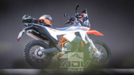
8 Great Reasons to Ride Washington’s Olympic Peninsula
Explore ancient forests, glacial peaks and roaring falls of the great North West.

You may not know it, but there’s a National Park the size of Rhode Island tucked away in the upper left corner of the U.S. The Olympic National Park, on Washington State’s Olympic Peninsula, is a treasure trove of wildland and wildlife alike.
Due to its remote location, it doesn’t receive nearly the same fanfare as other parklands and the same can be said about the region in general. That’s precisely why you should go: the Olympic National Park and greater Olympic Peninsula offer a unique opportunity to experience some of the areas greatest wonders without the Disneyland feel of Yosemite or Yellowstone. Also worth considering is the region’s extensive history of logging and forestry operations. There’s a seemingly endless system of primitive access roads that are begging to be explored by motorcycle.
We spent significant time on the Olympic Peninsula coming up with an epic adventure bike route that showcases some of the most intriguing natural wonders preserved within its borders. We also put together all the information you need to plan your own Adventure Ride in the region, including an interactive map, GPS tracks with top destinations, scenic camp spots and more. Read on for the eight reasons why you should stop what you’re doing and make a beeline for the PNW!
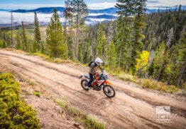
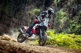
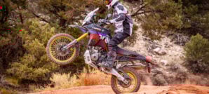
1. Epic Off-Road Terrain

Roadside hill climbs, tricky rockslide traverses, loose scrambles, and adventurous water crossings are all on the menu. With such a large sample size of terrain, there’s sure to be something to satiate everyone’s appetite no matter their riding ability or prowess. It’s quite easy to make a circumference of the peninsula on fairly basic dirt roads covering ground at a good pace while still having time to take in all the natural beauty.


That being said, there are plenty of alternate routes and side trips that are sure to fulfill those in search of a little gnar. This route is perfect for large displacement adventure bikes and smaller dual sports alike, all depending on pace and what kind of mischievous detours you want to undertake.
2. Explore a Unique Forest Landscape

The Olympic National Park is home to four temperate rainforests: The Hoh, Quinault, Queets, and Bogachiel. These forests are defined by their annual rainfall of twelve to fourteen feet each year. They are inhabited by old-growth Douglas fir, red alders, Western hemlocks, and Sitka spruce among plentiful varieties of mosses & ferns. Temperatures rarely fall below freezing or exceed eighty-degrees, facilitating a distinctively luscious ecosystem.

The park itself is comprised of nearly a million acres, seventy-three miles of coast, sixty named glaciers, sixty-four trailheads, and over three thousand miles of rivers & streams. It’s a vast swath of raw land set aside by the federal government for a good reason, as it is a wonder to behold. Some of the park’s notable animal inhabitants include elk, mountain goats, black bears, cougars, bald eagles, foxes, and plentiful deer. On the coast, sea lions, gray whales, orcas, and otters can also be seen.

Olympic National Park was the ninth most visited national park in 2018, hosting over three million people. Don’t let those numbers deter you; the high number of visitors is offset by the fact that ONP is the thirteenth-largest in the system (Comparable to Rhode Island). Notwithstanding the many tourists, adventurers on two wheels will often feel like they have the park to themselves. No other time is this personified more than in the shoulder seasons when some rain is almost guaranteed, but your reward will be empty campgrounds and absolute solitude.
3. Washington Coast


Washington’s coastline is one hundred & fifty-seven miles of beautiful breakwater where the Pacific Ocean ends or begins depending on how you look at it.
The beaches that comprise the Washington coast might not fit the classic mold of what most people envision when they picture a beach, but even on the most blustery of days, they still have just as much to offer. The seventy-three miles of beach designated as National Park is a unique ecosystem unmolested by modern complications and mostly inaccessible by vehicles. Sea stacks encompassed in fog banks often act as the backdrop for endless drift log strewn stretches of sand. Tide pools, rocks, and sea creatures are standard fare and can easily entertain one’s imagination for days on end.

Time off of the bike exploring sections of the coast is often just as enthralling as roving dirt roads and twisty pavement that often parallel Washington’s ocean beaches.
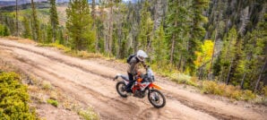
4. Amazing Views

The Olympic Peninsula is vast, and the landscape is diverse, even if it might seem entirely evergreen at first glance. Being able to travel from damp rainforests to expansive coastal beaches and then ascend mountains tall enough to take it all in represents something unique. Almost around every corner, another breathtaking view can be found, whether it’s the vast Pacific Ocean, regional volcanoes, metropolitan hubs off in the distance, or endless seas of densely packed trees.


Some of the must-see sights within the park are any of the temperate rain forests, Hurricane Ridge, Obstruction Point, Lake Crescent, Lake Quinault, Lake Cushman, Cape Flattery, and as many of the ocean beaches as you can pack in!
5. Complete Solitude
The Olympic National Park itself is nearly a million acres and although it sees many visitors annually, most of that traffic is allocated to a few hot spots that leave the vast majority tourist-free and ripe for exploration. Thankfully, in many areas of the peninsula, all it takes is a slightly deteriorated pothole-strewn road to deter most would-be wanderlust wanderers.


It’s not hard to find solitude on the Olympic Peninsula, and if that’s what you’re after, you’ve come to the right place. Even on a busy summer weekend, it’s easy to get away from the crowds as long as you avoid the established campgrounds and busy attractions like Hurricane Ridge. If you travel far enough down any dirt road, you’ll eventually have the peninsula to yourself; this is especially true on the South and West sides of our track.
Related Stories
Related Stories
 5 Must-Do Adventure Motorcycle Rides in Moab Moab, Utah is known as the Mecca of off-road recreation with seemingly endless...
 12 Unforgettable Spots to Explore on a Southwest Utah Ride Out of all the states in the American Southwest, Utah may be the...
 10 Majestic, Iconic & Odd Spots to Explore on a Death Valley Ride Death Valley, California can be one of the most uninhabitable places on earth...
Popular Stories
KTM 690 Rally Spotted in Near-Production Form
KTM’s “Adventure” models have become one of t...
2,500-Miles In 5 Days On A KTM 390 Adventure R. Here’s How It Went
You don’t ride long distances on the highway with...
Ducati Announces Specs & Pricing Of Street-Legal 450 Enduro Model
Ducati has officially unveiled the Desmo450 EDS...
Yamaha Launches First‑Ever Ténéré Trek Adventure Rider Rally
This summer, Yamaha is bringing its BLU CRU commu...
Notify me of new posts via email
Nice write up! Look sweet……and to someone who’s new to WA…..PERFECT!
Roads not worth it. Views not worth it. Weather not worth it. Locals politically minded and not friendly. Heavily regulated and patrolled. High fines. Go somewhere else.
Don’t do anything illegal, and you don’t have to worry about getting fined…
It sounds like you might have a bias or alternative motives, though.
I’ve been riding the Olympic Peninsula for going on 13 years now. It’s my favorite riding area. I’ve never had one single lick of problems with anyone or any regulation.
You forgot to say, “Stay off my lawn!” 🙂
I call BS on your review. I see that your post is from January 2020 so pre COVID. I can’t imagine what “Patrols and Regulations” you could be referring to? Rain in January, well yea, you did realize where you were going and the climate of the area for that time of year, right? All of the local people were friendly and kind to me so again, I’m stumped by your comments. I’ll return to this route time and again ow. It was a great experience.
Typical Trump voter.
I added this to my Gaia GPS, and made it public: https://www.gaiagps.com/public/ODSZlxqxS7ugpkAoavs6lBiv
Great article! Some of the best riding I’ve ever experienced. Can’t wait to go back!
The antiquated image of loud dirt bikes with careless operators is comical in this instance. We’re talking about modern motorcycles designed for road use, piloted by riders that have the means to own and maintain them. If I were you I would be more worried about the small army of transients and drug addicts that loiter in these areas, not to mention the hordes of beer drinking gun toting weekend worriers that leave behind unimaginable quantities of trash.
Regardless they tear up the terrain and like I said you better bring a chain saw and hope they are light enough to carry out. My sister lived in the area a month and a tree fell on her car.
Your basing your comments on your sisters one month experience? Trees fall in the PNW. As for motorcycles tearing up terrain, on logging roads? you have seen what mother natures erosion does, right? look at mother natures erosion on hiking trails. Motorcycles aren’t contributing to that at all.
So here’s a question – where is the nearest major civilisation ………..that would allow for hire of an adventure bike ?
Rob at Northwest Adventure Ride rents KLRs with luggage. A friend and I did this ride over the summer of 2019 on his bikes, and we had a blast.
Thank you for this article.
Great report Spencer! We’ve ridden all paved up there but always wAnted to do a more backcountry route. Nice to see you riding KTM now. I have always wondered what you have been up to so i’m glad to see this. Cheers my fellow shipmate! ERIC
While the riding season out here won’t be happening for a few months, Route 5 from Hoodsport to Quilcene still has part of it closed. FS 2441 from the intersection of FS 2464 to FS 2480, and the 2480 to FS 25 (Hamma Hamma road) are still closed due to the 2018 Maple Fire. The FS road closure document said it was to be closed until 30 OCT 18, yet it is still closed – confirmed that on a Xmas tree cutting trip up there in mid-December.
Hopefully, they will be opened up again this spring – call and let them know, and ask them to get the washout fixed on FS 2510 – IMO, one of the best sections on Route 5 – before the washout blocked it!
ONF Road conditions – https://www.fs.usda.gov/detail/olympic/alerts-notices/?cid=stelprdb5293706
This is an excellent write up Spencer! Thank you for this. I have been planning a trip here for summer ’20 and have been piecing things together through other sites. This article gives me all the info I needed, very much appreciated. I’m surprised to see negative comments on this.
Excellent article and some absolutely Beautiful pics! This is what I’m looking for as I move from dirt bike racing into a little slower pace as well as taking the time to smell the roses. I learned years ago that Adventure riding is just that,…..An Adventure. You have to be ready for anything.
Thanks for the ride report, AND the GRP files!
I spent five years in Oregon and had considered doing this ride many times, but never went for it. Now I have a reason to go back!
Thanks for sharing your .gpx tracks for this beautiful ride. We just rode a few shortend sections of the ride over three days. We started at Quilcene and rode a counter-clock-wise direction and ended at Lake Quinalt. I have a 1200 GSA that was fully loaded with camping gear with Heidenau K-60 Scout tires. I’m definitely looking for the easier less technical sections. The only section we hit that was not too comfortable was from Sitkum SolDuc road to Forks. At about 9 miles in, we started hitting some larger rock fall areas that were not so fun to manuever through with the Big Red GS. We did not know how many more of those we’d have to encounter in that area, so we did not continue with that section. Every other section was beautiful and fun. Thanks again.
Excellent ride. 3 of us rode clockwi
se September 17, 18 and 19. We psamrobably said hello.
Nice summary. Look me up if you want more tracks around Port Angeles and Sequim. Highway 112 to West Twin Rd to the Kloshe Nanitch fire look out is awesome for all sizes of ADV bikes. The Foothills ORV and Sadie Creek ORV areas have nice a flowy single tricks. There are more technical tracks around Cassidy Creek, Johnson Creek, Dry Hill, Gold Creek, and more. Look me up on FB if you want any of my GPX tracks.
Who wants to go with me?
I’m thinking of hading out to this ride this weekend or next.
Loved the article and enjoyed the ride. I was thankful for the GPX file and it led me through the routes flawlessly with one exception. Oly ride guide day 4 will take you to a washed out bridge crossing trout creek and there is no way to ford the creek. So when you come off NF 2294, go left on NF 22 as the guide suggests but don’t turn left on NF 2294-100 as the guide shows, it will dead end. instead, continue to NF 2312 on the east side of the reservoir and turn left. This will get you to the Wynoochee falls area and back on the route. Please note that I’m basing these comments on the topo map supplied with the article, the road that I took out of Satsop Center was actually 2270 and there are signs making it easy to find. I broke this leg of the route into two days, the second part of this leg is long. Stay at Satsop center, they’ll do your laundry for you for $4.00 (no detergent needed and my synthetic stuff didn’t get damaged), A shower is $3.00 (need your own soap, shampoo and towel) and camping is $20.00. A nice break and revitalization stop with friendly hosts. If you have questions or want interesting conversation with someone whos lived there and knows the area, talk to the Mayor of Satsop center.
Thanks for the info Tom. Two of us are headed over there tomorrow. I am wondering about campfires…. the DNR site makes it look like there are no campfires allowed at this time. But the Discovery Pass website has a burn ban notification but when you read it… its just for the Seashore conservation areas.
Thanks for the write up Spencer. I’m headed there next week and although this article is a bit older I’m sure all the routes are still there…along with the Olympic Forest! Can’t wait. Thom
Overall how was it following the gpx tracks? Pretty solid roads for 2 wheels? Any rough or difficult sections to avoid? Thanks
Thank you for posting the GPX files! Last week I camped at Coho campground, and rode up to Wynoochee falls (no one there, pristine) and then up toward Church Creek Trail for the view of the lake from elevation.
Just did sections 1 through 4 last weekend. The end of section 4 has a lot of blow down. Somebody has cut what is necessary to get a bike through but I still turned back to the mainline as I was getting low on fuel and my GPS was acting up on me. I was solo and didn’t want to have to turn back if the road wasn’t cleared the whole way cause I surely would have run out of fuel. I will have to do section 5 another day. Also section 2 is washed out and blocked at the west end but you can currently get a bike through both obstacles safely. I also skipped the loop on section 2 so I’m am not sure what the condition is like. I have pictures on advrider KTM 500 forum. Oh and yes you have to do that water crossing in the article pictures. It was easy on a 500 but anything bigger would be more challenging. I just slid my bike down the bank and went through there. There is a spot to ride down and over a long to the right, but then you have to come back on the rocky beach for the best place to cross.
This post and a few comments helped me when I was researching this ride. Thought I’d leave my experience for the next person.
I completed this route Oct 15-16th. I had planned and packed for a 3 day 2 night ride but with some sections being fixed and skipping some of the off loops I got it done in 2 days.
Traveling from the south I started on section 5 and ended on 4.
Section 5 started good but soon turned into a gravel highway. Seeing prius, civics, and corollas on a backcountry route is not my cup of tea. If you look on a map you can see through section 5 and 1 have the biggest amount of hiking trails. And are the closest for the city people to get too. Now knowing how incredible the other sections are I will never do section 5 and 1 from quilcene to carlsborg again.
Section 2 was amazing. Exactly what I’m looking for in a backcountry route. If your skipping the Sol Duc Hot Springs go past that road and turn onto 1918 to continue on the route. I skipped the loop in this section and cant wait to go back and ride it next year.
Section 2 has been closed to everyone but us, mountain bikers and hikers. You really get a feeling that it’s exactly why we ride a bike like this.
All the washouts have been fixed and they still have the gate up. So I highly recommend doing this section before they remove the gate and it looses some of that untouched feeling. It was truly magical.
Section 3 was fun. I skipped going to the Hoh rain forest.
Section 4 – After the town of Neilton you turn onto 2258 and this to the ending of section 4 was amazing. At Coho campground I turned right going to 2270 to get back on the route. This let me skip the river crossing section.
I really want to thank whoever cut down the rest of the logs over the last part of section 4. It’s the only reason I was able to do this route in 2 days. This part was wild all summer with the logs over the trail.
Again this is my experience and I’m putting this information up in hopes it will help another. If you have any questions you can message me on my instagram _jake_rawson_