LA2AZ: Off-Road From LA’s Urban Sprawl To The Border of Arizona
A 550-mile dirt loop across the Golden State to Lake Havasu and back again.

We’ve all heard of the legendary ‘LA-Barstow to Vegas’ (LAB2V) which occurs Thanksgiving weekend each year. The roughly 400-mile route, from North Los Angeles County to the bright lights of Nevada’s Vegas Strip, has been one of the most popular Dual Sport rides since its inaugural running back in 1984. More recently, the Backcountry Discovery Routes organization developed a pair of Adventure Bike routes traveling the vertical length of California, taking you some 1,780 miles from the border of Mexico to Oregon when connecting the two. But what about a route across California to its other bordering state, Arizona? And instead of one-way, let’s make it a loop so you can ride dirt back to your point of origin and see something completely different on your return?


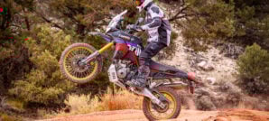
What we came up with is a route that takes you on a journey through impressive geologic formations, relics of the past, vast joshua tree groves, beautiful lakes, flowing creeks, extensive dune fields, thick pine forests, and tranquil camping under star-filled skies without another soul in sight. The trails keep it interesting as well, with a number of long scenic dirt roads that regularly mix it up with challenging sections that include rocks, ruts, sand, hill climbs, steep descents, single track, and more. One thing’s for sure, the view from your helmet is in constant change.


Sound like your kind of adventure? Let’s take a closer look at what’s waiting to be discovered…
The LA2AZ Route
Our journey begins and ends at the base of the mountains, at the edge of LA Metro’s urban sprawl, in the city of San Bernardino. Those looking to park a vehicle for a few nights can get in touch with Glen Helen Raceway, which is just a few miles away from the start of the trail.

We describe the route traveling from LA to AZ and back in a clockwise loop but there’s no reason you couldn’t follow these tracks going the opposite direction or choose a different starting point on the route. Just keep in mind, certain tracks may be more difficult going counterclockwise.
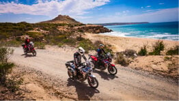
At its far eastern point, the trail takes you to the California/Arizona border at Lake Havasu. For those looking to ride into Arizona, you can continue on the powerline road down to the Parker Dam crossing. There is also a Ferry at the Havasu Landing Casino that will take you across the lake but it only transports people, not vehicles.
Day 1 – San Bernardino National Forest to Mojave National Preserve
Heading up Palm Avenue, the asphalt ends and the trail begins as you crawl your way up Bailey Canyon to an elevation of 5,400 feet with stunning views of the city you’ll be leaving behind for the next few days. As you reach the top of the hill, the landscape turns into a beautiful pine forest.

On the backside of the mountain, there are stunning views of the Silverwood Lake off in the distance. Continuing on through the hills surrounding Hesperia, the terrain changes to a high desert environment with scrub brush covering the landscape. Make a quick stop in town to top off gas before heading deeper into the desert. On a hot day, you can stop by the natural spring at Arrastre Falls for a quick cool off.


Riding through Lucerne Valley, you’ll enter a vast off-road playground that’s been home to countless Hare n’ Hound races over the years. The views extend for miles in every direction as you pass dry lake beds, intriguing rocky outcrops, active mining areas, and even a volcanic outcrop covered by ancient Native American petroglyphs. Powerline roads will lead you to your second gas stop in Ludlow where you can resupply.


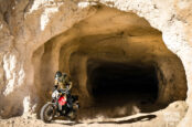
Back on the trail, you’ll begin to hit your first long sand section as you approach Kelso Dunes at the southern end of the Mojave National Preserve. The road is a wilderness corridor, so stay on the trail and begin looking for a place to camp for the night near Kelso Dunes or continue on into the Granite Mountains for some incredibly scenic camping in the rocks. If you’re on a good pace, you might make it to the Big Horn Mine where you can spend the night in an old miners’ cabin that’s been partially restored — a truly unique experience.


Day 2 – Mojave National Preserve to Lake Havasu
Continuing on through the southern Mojave Preserve, you’ll get an occasional glimpse of Interstate Highway 15 off in the distance. After gassing up in Fenner, you’ll head into the Piute Mountains with their beautiful craggy peaks. As you drop down into the Chemehuevi Valley, the trail calms, allowing you to soak in the views, but a set of high-speed rolling jumps keep the fun factor high.

Dropping down into the Chemehuevi Wash, there’s a fun sandy trail going through a small canyon. If you’ve had enough sand, you can bypass this section and stay on the road to town. Otherwise enjoy the trail as you start to get peeks of Lake Havasu off in the distance ahead.


Lake Havasu, a large lake created by the Parker Dam on the Colorado River, marks the border between California and Arizona. Head into the small town Havasu Lake, California where you can refill on gas, try your luck at the casino, or take the 16-minute ferry over to Arizona. There’s also a market where you can pickup some meat to grill and cold beverages for camp. Just a few miles south of town, you’ll find a nice sandy cove to camp in with views of Havasu City, Arizona directly across the lake on the other side.


Day 3 – Lake Havasu to Twentynine Palms
After riding south along the western shore of Lake Havasu, you’ll soon turn back west for the return leg of your journey. Traveling back through the Chemehuevi Valley, deep sandy tracks slowly turn into a rocky trail as you begin to see the jagged peaks of the Turtle Mountains come into view. Brown’s Camp offers a moment to get off the bike and explore old mining ruins of the area and even some old cars that were abandoned long ago.


Crossing Ward Valley, you’ll be back in the sand for a short time before you begin to see a new set of peaks in the Old Woman Mountains where the trail regains firmness. This area really gives you a sense of being far away from it all. The remote desert landscape is peppered with old mining relics to explore.


For those with smaller fuel capacity, you can head into Amboy for a stop at Roy’s Motel and Cafe (using the detour track) for fuel and supplies. Stop by the Amboy Crater while you are there to take a look at the dormant cinder cone volcano, which last erupted some 10,000 years ago.


For those continuing on, you’ll begin to see a vast sea of green come into view. The massive 9,600-acre farming operation pumps water from deep within the ground to feed the circular Alfalfa crops with thousand-foot-long robotic watering arms.

Deep sand reappears as you ride through Cadiz Valley on the final long straight before reaching camp. Keep your speed up to avoid sinking in! Stop at the Sheep Hole Mountains for the night and find a protective rocky cove to make camp, or if you’re looking for something more civilized, head into Twentynine Palms on the edge of Joshua Tree National Park where you’ll find gas, supplies, restaurants, and hotels. For those who find themselves ahead of schedule, there are additional camping options around Sunfair Dry Lake.

Day 4 – Twentynine Palms to San Bernardino National Forest
Starting day four you’ll travel around the outskirts of Twentynine palms. Just remember these are desert communities, so ride slowly when near homes. Cars can easily surprise you when entering blind intersections or there may be children at play. Those looking to experience their own childsplay will find a small dunes area near Sunfair Dry Lake. Or if you’re looking for something a bit more intellectually stimulating, stop by the Noah Purifoy Outdoor Art Museum to indulge in some strange and unusual sculptures.


Jumping onto Burns Canyon Road, you’ll start to see the terrain change back into a high desert landscape with thick brush intermixed with Joshua trees. The trail climbs up to the 5,000-foot elevation range before dropping back down into Rattlesnake Canyon. This undulating doubletrack wash is a mixture of sand and rocks that is both challenging and incredibly fun to ride. You’ll also find fun desert single tracks to explore in the hills surrounding Hesperia before your final gas stop in town.


After a short pavement ride, you’ll jump back on dirt to explore the coastline of Silverwood Lake. There are a couple of areas where you can ride down to the water for a quick cool-off on the beach but you may find it pretty crowded on a weekend. Stay alert for oncoming vehicles as this area is a popular OHV trail. After heading up Pilot Rock trail and through Miller Canyon, you’ll start to ascend into the forest again. Sawpit Creek bridge is another excellent spot to cool off with a beautiful waterfall to check out. As you reach the top of the mountain, stop by historic Monument Peak to enjoy the view and say hello to civilization again. The final 6-mile descent down Bailey Canyon takes your back to where you started your LA2AZ journey.


Riding Terrain
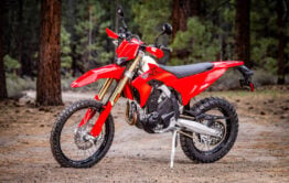
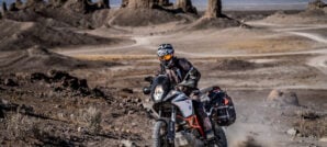
Some may ask is this a Dual Sport or Adventure Bike route? It’s something in between, leaning more in the direction of a Dual Sport route. While it is doable on a Big Bike with a set of 50/50 knobbies and good off-road riding experience under your belt, it is not 100% Big Bike friendly. There are definitely long scenic sections that follow powerlines or railroad tracks, yet there are many tricky sections too that will give even Small Bike riders a challenge when loaded down with camping gear.

Like anywhere in the California desert, you can expect plenty of sand. And while the route can get very remote at times, the nice thing is the highway is usually close by should you encounter bad luck. Riding with a buddy is always a good idea though, as well as a GPS messaging device because cell service is spotty.
The route travels on dirt about 94% of the time with a few asphalt sections to get you to gas stops. The longest range you’ll need between fill-ups is about 140 miles, but if you take the gas detour to Amboy the longest section between stops drops to 110 miles. Your mileage may vary though, deep sand and/or getting lost may increase expected fuel consumption. A typical small thumper Dual Sport with a stock tank should carry a little extra fuel or upgrade to a larger desert tank. It’s always smart to bring more water than you think you’ll need as well when traveling in the desert.


The entire LA2AZ route is about 550 miles and it will take you about 3 nights and 4 days on average to complete when riding at a solid pace. In the winter with shorter days, you might need to account for more time. With any route of this magnitude, you can expect there’s going to be surprises. Trails can become damaged, blocked, degraded, or disappear. Be ready to improvise, use good judgment, bring paper maps and your GPS to re-route and get back on track if needed. Prepare for the inevitable mishap and remember it’s all just part of the adventure.

Weather
With a route such as this one that travels through both mountains and desert, you’ll need to bring layers and be prepared for temperature swings and potential bad weather. The best time of year to plan this trip is anytime ‘except’ mid summer, as it is usually well over 100° F between July-September in the desert. The tracks reach a height of 5,700 feet in the San Bernardino Mountains, which is an elevation that usually receives a light amount of snow during the winter but you’ll want to check the forecast to avoid any serious storm systems during your trip. We’ve gotten some heavy snow storms during the last few seasons that would put parts of this trail under feet of snow, but that’s more of an unusual occurrence. The route has been designed to stick to lower elevations making it a perfect getaway during the winter months.

Camping/Lodging
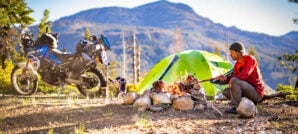
The LA2AZ route includes several suggested camping waypoints along the way that are marked on the tracks, giving you options to stop for the night sooner or later depending on your progress. Rough camping is allowed on federal land but keep in mind fires are usually restricted year around in the San Bernardino National Forest due to the high fire danger in the area. Other restrictions apply such as campfire permits and distance requirements from roads or bodies of water, so check the current rules.
Those looking for more amenities will find established campgrounds with toilets and showers around Silverwood Lake, and even lodging options around Havasu City and Twentynine Palms. Just be aware there aren’t any Campgrounds or Hotels near the trail once you are past Lucerne Valley, until you get to Havasu City or between Havasu City and Joshua Tree NP.
Maps and GPS Tracks
Want to do this ride? A large interactive map and downloadable GPX Tracks are available free. * Note: Zip downloads don’t work with the Facebook app. Download using a regular browser such as Chrome, Safari etc.
* Terms of Use: Should you decide to explore a route that is published on ADV Pulse, you assume the risk of any resulting injury, loss or damage suffered as a result. The route descriptions, maps and GPS tracks provided are simply a planning resource to be used as a point of inspiration in conjunction with your own due diligence. It is your responsibility to evaluate the route accuracy as well as the current condition of trails and roads, your vehicle readiness, personal fitness and local weather when independently determining whether to use or adapt any of the information provided here.
Photos by Ely Woody and Rob Dabney
Author: Rob Dabney
Rob Dabney started a lifelong obsession with motorcycles at the age of 15 when he purchased his first bike – a 1982 Honda MB5. Through his 20’s and 30’s he competed in off-road desert races, including the Baja 250, 500 and 1000. Eventually, his proclivity for exploration led him to dual sport and adventure riding. Rob’s never-ending quest to discover what’s around the next bend has taken him on Adventures in Latin America, Africa, Europe, Asia, and throughout the American West. As a moto journalist, he enjoys inspiring others to seek adventure across horizons both near and far.Related Stories
Related Stories
 ADV Destinations: The Abandoned Pumice Mines Of Red Rock Canyon The Mojave Desert is one of those places where history and geology often...
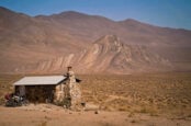 ADV Destinations: Geologists Cabin At Striped Butte In Death Valley Tucked deep in the southern reaches of Death Valley National Park, Striped Butte...
 Millions of Acres of Public Land Face Sale Under New Senate Bill Adventure riders rely on public lands, whether it’s carving desert two-track in Arizona...
Popular Stories
Sena Launches Their First Dual Sport Helmet
Sena is expanding its smart‑helmet lineup again...
Ducati Announces Specs & Pricing Of Street-Legal 450 Enduro Model
Ducati has officially unveiled the Desmo450 EDS...
Honda Debuts Adventure Motorcycle Film On Streaming Platforms
Honda is bringing its flagship adventure‑tourin...

Classic Meets Modern Rally In This Dialed Honda XR600R Build
For many riders, the XR600R needs no introducti...
Notify me of new posts via email
Such a badass ride! Already making plans to do the whole thing.
This looks incredible!
Looks like a great adventure thanks great pictures also
It’s not a ‘border’… it’s a state line.
What a waste of comment.
If you use a garmin devices, suggest looking at the free map overlay creator – takes the gpx files and converts them into a fat line map with other features. See here: https://mapmaker.tricktracks.org/server/trick_tracks/file_uploader.php