12 Unforgettable Spots to Explore on a Southwest Utah Ride
Discover a land of towering red rocks, mysterious canyons & endless surprises.
6. Grosvenor Arch.

Grosvenor Arch is a unique masterpiece of nature. Just off of scenic Cottonwood Canyon road, this rare double arch structure sits high atop a majestic sandstone cliff 150 feet above the ground. Wind and water have skillfully carved away the stone over the ages to reveal an arch with a span of nearly 100 feet.

A short walk on a concrete path allows you to get right underneath the double arches to view this massive sandstone formation in all its glory. It’s a remarkable sight up close and one of the most photographed locations in the Grand Staircase Escalante National Monument area..
7. Warm Creek Bay, Lake Powell

Warm Creek Bay in the Glen Canyon National Recreation Area is a popular site for houseboaters, with many sandy beaches and several hidden coves that offer private camping opportunities. The area provides a change of scenery during your ride with commanding views of Lake Powell’s red rock shorelines.

Getting to Warm Creek Bay is half the fun. The creek bed trail takes you on a thrilling ride through a canyon with imposing cliffs on either side. The terrain has an eerie appearance like it was once underwater. You’ll also notice three enormous smoke stacks (775 feet tall) off in the distance, which are part of Arizona’s Navajo Generating Station. Luckily, these are out of view once you reach Warm Creek Bay..
8. Bryce Canyon

Bryce Canyon is the second National Park that can be visited on a tour of Southwest Utah. Bryce is famous for its otherworldly geology, consisting of a series of horseshoe-shaped natural amphitheaters filled with colorful pinnacles rising as high as 200 feet. These delicate pillars of rock known as hoodoos were formed by thousands of years of frost weathering and rain erosion on sedimentary limestone.

Bryce Canyon has the largest collection of hoodoos in the world and the red, orange, and white colors of the rocks provide unforgetable views for park visitors. And with the park’s rim sitting at about 9,000 feet above sea level, spectacular snow-covered hoodoos can be viewed well into April.

Bryce Canyon is actually a series of different amphitheaters extending more than 20 miles across the park, the largest of which is Bryce Amphitheater at 12 miles long, 3 miles wide and 800 feet deep. The ride through the park out to Rainbow Point offers dozens of different outlooks with epic scenery but if you are pressed for time, the Fairyland Canyon Overlook provides an opportunity to see a variety of hoodoos without entering the park..
9. Red Canyon

Red Canyon is a hidden jewel of Southwest Utah many travelers to the area overlook. Located along Scenic Byway 12, Red Canyon offers numerous red rock structures to explore just steps from the road. The familiar pinnacles, spires, and hoodoo formations are similar to neighboring Bryce Canyon, but on a smaller scale. The nice thing is that you can interact with this unique landscape up close, without the big hike required at Bryce Canyon. And since most visitors fly right past Red Canyon on their way to Bryce and Zion, the park has fewer crowds.

Some of Utah’s most photographed tunnels can be found in Red Canyon on scenic Highway 12 and there are also numerous OHV trails to explore in the area if you are looking for something more adventurous. Red Canyon is well worth a visit and you can easily spend a few days discovering the area..
10. Brian Head Peak

Just north of Zion National Park, in the Dixie National Forest, is Brian Head Peak. At 11,312 feet elevation, Brian Head Peak is the tallest mountain in Southwest Utah. A 3-mile dirt road (Brian Head Vista Road) off highway 143 takes you all the way to the top of the mountain. The summit is broad and flat with fantastic views in all directions. A small stone hut sits at the peak that was once a forest service fire lookout.

The summit’s hundred-mile views allow you to see as far away as Wheeler Peak, Nevada and Mount Trumbull, Arizona. Closer by, you can see stunning views of the Red Rock formations of Cedar Breaks National Monument and the Paunsagunt Plateau (backside of Bryce Canyon). And directly below the summit, the town of Brian Head and its famous ski resort are visible. Getting to Brian Head is a sporty ride up a fantastic mountain road with incredible vistas as you gain roughly 5,000 feet of elevation..
11. Cedar Breaks National Monument

Just three miles south of Brian Head is Cedar Breaks National Monument. Cedar Breaks is a giant red rock canyon, shaped like a coliseum. Its rim is situated at an elevation of 10,000 feet and stretches three miles across, with a depth of over 2,000 feet. Cedar Breaks looks similar to red rock formations at Bryce Canyon but with even more brilliant color. The many layers of the canyon walls include shades of red, yellow, white, pink and orange, while lush green pine forests top the rim.

Millions of years of deposits, uplift and erosion carved this bowl with intricate spires, columns and pinnacles. The Southern Paiute people, which were the original inhabitants of this area, fittingly named Cedar Breaks “U-map-wich” translated as “the place where the rocks are sliding down all the time.” Three different overlooks just off the highway offer amazing views but Point Supreme is the most impressive. Average daytime temperatures are around 60 degrees in the warmer months, so it’s a good place to escape from the heat. But be aware that evening temperatures can drop below freezing (even during mid summer) if you decide to camp there..
12. Toquerville Falls

Toquerville Falls is a secluded “local’s spot” just outside of St. George, and the bumpy 4×4 access road ensures only the most determined get to enjoy its charms. For most of the 5.8-mile drive, the rocky arid desert scenery is unchanging, until the end of the trail when a lush oasis around the falls bursts into view. Your reward after a rough ride are beautiful cascading waterfalls fed by La Verkin Creek.

On a hot day, you can lay back in one of the many rock recliners and enjoy the cool waters. Or take the ladder down to the lower pool for a dip in the swimming hole that offers waist-deep water even during summer months. It’s the perfect refuge from the heat and soaking in the pristine waters of Toquerville Falls is a fitting end to a ride across Southwest Utah.
Planning Your Trip

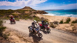
Riding Terrain: The route is 40% dirt and 60% street in mileage but more time is spent on dirt due to slower traveling speeds. The asphalt portion includes beautiful scenic twisty roads through Zion, Escalante, Bryce Canyon and Brian Head. Dirt roads through Warner Valley, Smithsonian Butte, Skutumpah Road, Cottonwood Canyon and Hole in the Rock Road are all smooth and easy. Short sections of the route can be technically challenging like the sandy track through Fort Pearce Wash or the rocky road to Toquerville Falls. Smokey Mountain road through Grand Staircase Escalante National Monument is also somewhat challenging and includes a few long sections of sand.
All sites on the route are accessible to large 1000cc+ adventure bikes but at least an intermediate level of off-road riding experience is recommended. Some of the more technical sections can be bypassed by planning ahead. The furthest distance between gas stops is about 120 miles. Some areas like Grand Staircase Escalante are very remote and you may encounter few other people out on the trails. It’s a good idea to ride with friends and bring ample food and water, first aid and an emergency GPS messaging device.
Weather: Spring and Fall are the best times to visit Southwest Utah. It’s possible to ride some of the route during Winter but many sections may be covered by snow and closed to traffic. Temperatures soar above 100°F (38°C) during the summer in the lower elevations but maintain comfortable temperatures in the higher elevations around Bryce Canyon and Brian Head. Elevations range from 2,500 feet to 11,000 feet, so be prepared for a wide range of temperatures and wear good breathable riding gear that can handle swings in the weather.
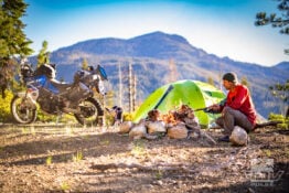
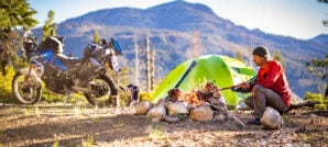
Camping: There are many different options for camping in Southwest Utah from developed campgrounds to backcountry camping in remote areas. Coral Pink Sand Dunes campground offers developed camp sites with fire rings, picnic tables, hot showers and flush toilets for $20 per night, while nearby Ponderosa Grove Campground has more primitive camping sites and a bit more solitude for $5 per night. Warm Creek Bay offers backcountry camping along the shores of Lake Powell and there are great wild camping opportunities all along Skutumpah road near Cannonville. Devil’s Garden Campground is another developed site with flush toilets, picnic tables and fire rings for $25 per night. Developed campsites with showers are available near Red Canyon and Cedar Breaks for about $20 per night, but beware of freezing nighttime temperatures in these higher elevation areas.
Gear We Used
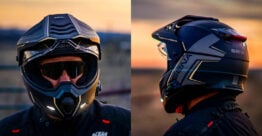
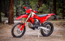
During our expedition to Southwest Utah, we encountered a multitude of different terrain and extreme variations in temperatures with elevations ranging from 2,500 to 11,300 feet. It was the perfect opportunity to put our riding gear and luggage systems to the test. The devices we used to navigate our way and stay connected also enabled us to explore this remote region with confidence. Here’s a list of some of the products we used on the trip that impressed us..


You can read more about how these products performed during our expedition, on our Tumblr Page.
Maps and GPS Tracks
We’ve put together a route that will allow you to visit all of the places listed in this Ride Guide during a 3- to 4-day trip. A large interactive map and downloadable GPX Tracks are available free.* A paper map is always good to have as a backup as well.
* Terms of Use: Should you decide to explore a route that is published on ADV Pulse, you assume the risk of any resulting injury, loss or damage suffered as a result. The route descriptions, maps and GPS tracks provided are simply a planning resource to be used as a point of inspiration in conjunction with your own due diligence. It is your responsibility to evaluate the route accuracy as well as the current condition of trails and roads, your vehicle readiness, personal fitness and local weather when independently determining whether to use or adapt any of the information provided here.
Author: Rob Dabney
Rob Dabney started a lifelong obsession with motorcycles at the age of 15 when he purchased his first bike – a 1982 Honda MB5. Through his 20’s and 30’s he competed in off-road desert races, including the Baja 250, 500 and 1000. Eventually, his proclivity for exploration led him to dual sport and adventure riding. Rob’s never-ending quest to discover what’s around the next bend has taken him on Adventures in Latin America, Africa, Europe, Asia, and throughout the American West. As a moto journalist, he enjoys inspiring others to seek adventure across horizons both near and far.
Related Stories
Related Stories
 8 Great Reasons to Ride California’s Giant Sequoia Forests 5. Getting Away From It All The extensive alpine woodland of the Sequoia...
 Ride Guide: 10 Must-See Sites in the Mojave National Preserve 6. Lava Tube Cave. One of the most popular attractions in the Mojave...
 10 Must-See Sites On A Ride Thru Lassen Volcanic National Park Nestled in California’s northeastern corner lies Lassen Volcanic National Park and the surrounding...
Popular Stories
Sena Launches Their First Dual Sport Helmet
Sena is expanding its smart‑helmet lineup again...
Ducati Announces Specs & Pricing Of Street-Legal 450 Enduro Model
Ducati has officially unveiled the Desmo450 EDS...
Honda Debuts Adventure Motorcycle Film On Streaming Platforms
Honda is bringing its flagship adventure‑tourin...
8 Simple Things To Make Moto Camping More Comfortable
For adventure riders, camping can be a divisive t...
Notify me of new posts via email
Very nice Utah travel article! Weber State grad-1982!
Glad you liked it Mark. And good to hear that from a Utah Native. Thanks!
Great article! Thanks for the GPS tracks!
Thanks Al. Hope you get to ride this area soon!
That Warner Valley ride is a favorite of mine. Good fun.
Love visiting the “Mountain Meadows Massacre site.
Yes, there are a lot of interesting spots to explore in and around that Warner Valley area. And some great riding too!
You drove right by the most beautiful canyon of all, Kolob Canyon, a part of Zion’s just off I-15 north of Toquerville Falls. It’s a short, paved ride but has amazing views
So many great places to explore in Southwest Utah. Kolob Canyon is definitely worth a visit.
But Bryce Canyon IS a canyon. There is a 30 mile hike that goes along the bottom of it.
Why were all those people killed at Mountain Meadows?
We just did a modified version of this and feel like we were a couple weeks too early in the season as we had to bail on a few dirt sections due to mud and had to high-tail it out of the Bryce Canyon area due to impending snow.
Here is one idea for those riding the area that worked well for us. If you trailer your bies to the area, you can park at the St. George Airport for $5 a day. The back of the lot has longer spots to handle a tow vehicle and trailer. Adjacent to the parking lot is a self-serve gas station where you can drop the bikes and get prepped for your tour. Then move the vehicle/trailer to secured parking, walk back to the gas station, fuel up and off you go.
Awesome are to ride.
Great tips on the vehicle drop Tim. Thanks for sharing!
Are the tracks still available? I am unable to find them in REVER
Sure. We just updated the link so you can download the GPX file directly.
Awesome! Ill be heading out at the end of Sept
I love these wild, rugged, and beautiful sites and the descriptive writing about them.