Owens Valley: Riding in a Land of Ever-Changing Terrain
A diversity of landscapes to explore stuffed between two giant mountain ranges.

Fortune favors the bold. However, sometimes fools rush in where wise men fear to tread. As adventure riders, it seems we occupy some twilight zone between these two ideas. We try to plan things out as best we can, and simply accept whatever results come. In the vast majority of circumstances, interesting discoveries and rejuvenating experiences are the outcomes of whatever travel recipes we assemble. And sometimes, like a steak slathered in VapoRub, things might look fine from a distance, but turn out to be ideas which are more wrong than one could have imagined.

Owens Valley, and the Eastern Sierra Corridor, is one of those rare gems on earth which contains an almost perplexing diversity of terrain to experience. In the sky, on the ground, and even under the ground, this portion of Central California is an adventurer’s paradise. For terrestrial travelers, the diversity contained here can be explained to a degree with the simple observation that the highest point in the contiguous United States, Mount Whitney (14,505 foot peak elevation), and the lowest point in all of North America, Badwater Basin (282 feet below sea level), are less than 90 miles from one another, as the crow flies. The valleys crammed between these two extreme points contain all the geographic and historic diversity one would expect from such contrast.


As a corridor, exploring the Eastern Sierras is relatively convenient when compared to traversing some of the expansive deserts in the West. Defined by a massive mountain range on one side, with almost no passable routes crossing it, and the desert of Death Valley on the other, riders are fenced into a prescribed adventure playground. It’s a 2,000-square-mile playground, however, so there’s plenty to see and do.
This exploration was unintentionally split into two separate trips, which resulted in covering vastly more ground, and seeing more points of interest than were originally planned. Trip number one started like most adventure bike rides out of Southern California do — a long pavement drone connecting a series of freeways to escape the concrete coating of urbanity. The difference in this case, was that it was hot. Heat is the norm in the southwest corner of the U.S. during summer, but there are those rare days which start breaking records. In the case of this week, records for highest-ever recorded temperatures were being melted.

You know it’s hot when you’re thankful that the number on the bike’s temperature gauge only starts with an 11, and not a 12 —115°F. That’s what the Trail Tech Voyager Pro was telling me as we pulled off the pavement and started riding up the youngest cinder cone volcano in the Fossil Falls region of Owens Valley. The deep hues of Red Hill absorbed the sun and gave back heat which served as a reminder of the area’s fiery history. Fire and ice literally shaped this landscape. Smooth, twisted rock formations cutting deep trenches through Fossil Falls were created as melting glaciers sent water down through the valley, carving the lava flows over thousands of years into their present shape.

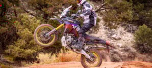
Rock turned to sand as we rode north toward Olancha and entered the dunes area. Having already wrung out the 390’s comparatively diminutive engine over miles of super slab in sweltering heat, I had some hesitation about taking it straight from that into sand dunes. Being more accustomed to the power of my KTM 1090R in the sand, it was a welcome surprise to find the little single’s power-to-weight ratio seemed to work out. What felt like half the motorcycle I’m normally used to, calmly floated over top the white landscape, fully loaded for the next few days of camping.

Out of the dunes, we head east, and closer to Death Valley. Only the most unusually hardy of souls decided to spend their existence out here. Why one chooses a life of mostly solitude, eking a living out of the ground in almost impossibly hostile conditions, seems a mystery. Maybe not so much a mystery, when one considers violence seemed to define most communities around here. Apparently breaking rocks in sweltering heat or pitch black mines all day doesn’t make one soft and fuzzy.


If it weren’t for such beautiful terrain, a tour through this area can sometimes give the impression of Hardship’s Greatest Hits. Looking at the human condition through the lens of desert travel around here seems to negate the idea of extraterrestrials seeing the Western deserts as a desirable vacation spot. Any Alpha Centaurian with half a brain (or whatever they use) would look down on approach at Cerro Gordo in its heyday, and wisely change direction.


This small silver mining community perched at over 9,000 feet in the Inyo Mountains at one time had the distinction of being the most violent town in the United States. Active mining operations ceased in about the mid-1930’s. For the next 80 years or so, Cerro Gordo remained largely a ghost town until 2018 when it was purchased by a group of private investors. For the moment, travelers are still welcome to pass through, just be respectful that this is a private residence now. While quite steep and littered with treacherous curves, the main road to Cerro Gordo from the Owens Valley side is smooth and well-maintained. For riders wanting more of a challenge, the path to the community from Saline Valley to the east is an unmaintained, rocky, steep, and sandy path.
If the ride up to Cerro Gordo from Saline Valley didn’t present enough challenges, there’s an extra-credit option: The Saline Valley Salt Tram. One goal of this trip was to get there and explore some of the ruins. We’d already experienced our share of (perhaps) old-school style hardships just getting to the town. Flat tires, running out of water, a slightly fried clutch on one of the bikes, and following what we thought was an optional route to Cerro Gordo, that turned out to be vastly more challenging than the main route, ending at a massive landslide perched on a steep cliff. At this point, we were kind of in survival mode. We still had plenty of resources at our disposal, we just needed to use them wisely.


Wrestling the bikes around the piles of rocks waiting to fall down in the mountain in scorching temperatures well over 100 degrees, we eventually got down the hill, and started up the proper (still challenging) route to Cerro Gordo. This road becomes much smoother as one nears the top of the mountain, and our overall confidence about things began to return. Finally getting to town, being greeted by the owners, having some water on an impromptu tour, all factored into the idea of, “well it really wasn’t that bad… let’s go for the Salt Tram.” The sideway glances from our Cerro Gordo tour guide and mention of a recent airlift rescue on that road should have been a hint.
The road to the Saline Valley Salt Tram is like eating Ghost Pepper Sriracha sauce. It starts out so good, then suddenly starts to hurt, and you can’t escape. After cresting one of the ridiculously steep, sandy, and switchbacky sections, I paused atop the hill on the KTM 390 Adventure to wait for the other two bikes. A long pause turned into concern and I decided to circle back to check on the situation. Having been put through the gauntlet on this trip and several previous ones, the slightly fried clutch on the Himalayan was now fully cooked and we were stuck in the base of a deep v-shaped valley, with steep climbs in both directions to get out.

Looking down at Owens Lake from 9,000 feet feels like you could easily just hike there. It isn’t until you’ve got a handful of motorcycles stranded in a high valley that it sinks in just how far away that place down there really is. We decided to tow the bike out with the 390 Adventure but with gearing designed for cruising down the highway at 80+ mph, we were stopped just shy of the top when wheelspin kicked in on the loose, rocky climb. Thus the third bike in the group, a Suzuki DR-Z 400 came to the rescue with its lower dirt bike gearing. After a lot of luggage swapping, hiking, towing, tow-strap-breaking, tow-strap-fixing, and towing some more, we finally got out of this predicament, and made it back to the home base of Lake Olancha RV Park. Although, it might have been the following day. I don’t recall. It was dark.

Having been so close before the mechanical mess ensued, the Salt Tram remained an unscratched itch, which bordered on a vexatious memory. We had to go back, both to accomplish that goal, as well as to check out several other routes and locations. A second trip began a few weeks later after repairs were made, of course, in the middle of another record heat wave. To break things up, it was decided the western approach to the Salt Tram would be attempted. The ride up from the Swansea side is a rocky version of the same song as the Cerro Gordo side. Starting out like a familiar rough desert road, the path eventually leads to sections that make you want to get off and walk first, just to be sure they’re passable. In the end, it’s all very doable, but not for the faint-of-heart.
As we passed the first of the tramway tower ruins, both the trail itself and offshoots for photo ops and such became more technical. A couple close calls started bringing up reminders of just a few weeks ago on the other side of the mountain. As this was just the beginning of the first day of this trip aboard our again fully-loaded adventure machines, we elected to cut the climb short shy of the peak. Unbeknownst to me at the time, another trip was already in the planning stages, involving some very unique dual sport machines, the Salt Tram, and even more technical trails. Stay tuned…


Back to hardship. 10 miles north of Lone Pine, California, is the Manzanar National Historic Site. From 1942 to 1945, as many as 10,000 Japanese-Americans were incarcerated there following the December 7th attack on Pearl Harbor. Many of the original building’s foundations remain in place, and the grounds can be toured. An interpretive center holds remembrances, photos, and other information about the infamous history of this location. Off-road options exist to get to the Manzanar site, but its location just off highway 395 allows for an all-paved route to visit.


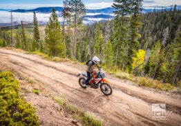
Some portions of Owens Valley have simply never seen development, of any kind. Whether for lack of mineral resources or other reasons, these areas have always remained remote and untouched, other than by the few dirt paths cut through them by adventure seekers. Papoose Flat is one such area. This high plateau holds some of the most stunning scenery in the form of vast valleys and rock formations to be found in this part of California.

Moderately technical riding on the western trailhead is a fun challenge, rewarded with numerous campsites among the Pinyon Pines in the upper elevations, or expansive vistas of the Flat itself. We only had a loose idea of the general area we wanted to camp in. Sometimes no plan is the best plan, as pausing for a photo op led to an impromptu check of a side road, which ended at a stunning campsite, complete with a mini rock-arch.


White Mountain is interesting for a variety of reasons. Perched atop the third highest peak in California, at 14,252 feet, the White Mountain Research Station studies the effects of altitude on physiology. Just below where a research facility is studying aspects of survivability, the longest-surviving things on earth still grow quietly in the Bristlecone Pine Forest. Parking between a Prius and a kitted-out Sprinter van, then taking a stroll through living things that were born in the Bronze Age, does put one’s time on earth in perspective.


The main road through to the Bristlecone Pine Forest visitor’s center is entirely paved. Shortly after the visitor’s center, the road turns to graded dirt, which leads all the way to the White Mountain Research Center. Silver Canyon is a much steeper brake-eating option which descends what seems like straight down to Bishop. The backside of White Mountain has numerous roads to explore as well. Just think twice before taking fully-loaded adventure bikes down that unknown path on your GPS that reads “Singletrack?”.


Out of the mountains and back in the valley, Fish Slough is a wide, smooth, and fast road which begins just outside of Bishop. Yet another one of those oddly scenic and convenient spots with little infrastructure, history is in plain sight just off the road. Mystery surrounds the Fish Slough Petroglyphs. Guesswork says the Paiute-Shoshone people who still inhabit Owens Valley possibly created them. Dates for when they were created range from 1,000 to 8,000 years ago. These petroglyphs peer east towards the road’s namesake. The dust of Fish Slough road eventually gives way to lush fields, and later to water being directed by sluice gates, allowing for small ponds, teeming with life.


Having traveled this portion of the Owens Valley many times, as the afternoon light began to fade into evening, I wasn’t concerned about our destination of Shepherd Hot Spring. It’s not that far, so yes of course, let’s check out a new route on the way. Apparently the Himalayan’s clutch wasn’t privy to our conversation, and took some other route, as the slipping returned in one of the steepest sections of this rather amazing road leading away from the petroglyphs. Fortunately, it turned out merely to be an adjustment hiccup with an aftermarket clutch, although we didn’t know it at the time in the waning light. Arriving at the hot spring in the middle of the night might as well have been rolling up to the best five-star hotel you can imagine.


Pumice and steepness best describes most of the trails around Mammoth Mountain. It’s challenging adventure riding terrain, painted into a gritty postcard scene. It might seem like you’re not far from a paved road in any one direction, but it’s going to take a lot of turns to get there. Sometimes, when the turns stop, the sand starts. Descending out of Sage Meadows, to the south-east of Mono lake, things get sandy. A rarely-ridden two track meanders into the deep sand, which eventually becomes low dunes. The mostly stark white landscape is composed of a mix of pumice, fesh fesh, and medium-sized rocks. It’s a fun challenge that makes vehicles moving along route 120 a welcome sight towards the end of a long, difficult section of trail.
Mono Lake is a massive body of water, over 60 square miles, which is constantly fed with fresh water from the mountains. With no outlet, the salinity and alkaline nature builds up to much more than that of the Pacific Ocean. No testing is necessary to be aware of this fact, as large calcium carbonate limestone towers, known as Tufas, can be seen poking up both from the surface of the lake, and on dry land where the lake waters have receded. Walking a small interpretive path through the Tufa towers links together signs showing the receding lake level over the years, which revealed the towers and halted their growth.


Between the challenging riding and hiking interpretive trails, a trip like this builds up an appetite. Stopping into a Mobil station for food wouldn’t normally be the optimal choice, but it is the stuff of road-trip fare. The Mobil station in Lee Vining, however, is no normal gas station. Inside, one finds the typical convenience store setup, maybe just a bit larger than normal, and tucked at the far end is the main feature – the Whoa Nellie Deli. Chef Matt Toomey has created a casual gourmet diner that adds a whole new dimension to “fill up”. Once you’ve got the bikes taken care of, skip the energy bars and pop in for some fish tacos with ginger coleslaw and wasabi crème fraiche (my personal favourite). One of my adventure goals, someday, is to explore the rest of the menu. For now, that mango salsa still has its talons in me.
Stopping at Whoa Nellie Deli was the perfect jumping off point, late in the day, to head over to Silver Lake to camp for the night. Grant Lake offers a bit more space, and an unimproved setting, but the active campground and nearby restaurant at Silver Lake were a welcome break from the hard travel the past few days — we just had to be ok with sharing it with what seemed like 500 of our closest buddies, and a deer that just about spent the night in my tent.


Back to the trails of Mammoth, the riding between June Lake and Mammoth Lake can be tough. Very steep terrain, deep pumice, abundant rocks, and tree roots snaking across some trails greeted us the whole way. The well-marked trails allow you to choose your own adventure, to a degree. Sticking to the June to Mammoth loop proved fun and challenging enough on fully-loaded adventure bikes. Fortunately, we opted to limit the extra-credit sections through this early part of the day as things would soon get more challenging.


It’s difficult to choose the best aspect when it comes to Owens Valley. Massively disparate elements all beg for attention in different ways. Saving the best, or most unexpected, for last, Coyote Flat, on the eastern slope of the Sierras comes with the most pronounced admonishment for adventure bike riders – this is extremely difficult terrain.
The scenery, primitive camping, and massive vistas of Coyote Flat from heights reaching 11,400 feet are like nothing that can be experienced anywhere else in California. Azure-blue glacial lakes captivate the eyes, as do the actual glaciers, including the Palisade Glacier, the largest glacier in the Sierra Nevada Range.


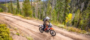
Ascending from just outside of Bishop to the north, the road to Coyote Flat, is exceptionally steep, and quite rocky in spots, however a reasonable path for an experienced adventure bike rider. The route between Coyote Flat and Big Pine to the east is a highly technical jeep trail, and should be reserved for only the most experienced adventure rider. Even for those with the skills to make this trek, a prudent move is to use this route as a descent on a first run from this high valley. As a climb, a few sections resemble something better suited to a sub-500cc dirt bike versus anything with more than one cylinder. Even heading out from the top towards the Big Pine side of things, one has to climb before they can descend. While I’m definitely a fan of big-twin adventure bikes, the 390 Adventure’s vastly less imposing mass and lower overall height became more confidence inspiring, as the descents became continually more steep.

At 4.5 billion years old, history surrounds us no matter where we are on this planet. Some places just make it more difficult to see and experience than others. Traipsing through the glitz and price tags of Rodeo Drive in Beverly Hills doesn’t bring to mind following in the path of dinosaurs, until you head about three miles east and see the La Brea Tar Pits. Owens Valley is a dense collection of modern and ancient history, all in plain sight, and distilled into an adventure-rich setting.

A trip through here can be as extreme or as tranquil as one desires. Be aware, the most tranquil excursion out here can quickly turn extreme, so bring plenty of water. And tools. And, depending on the route you choose, aftermarket parts made by Vice-Grip.
Photos by Stephen Gregory, Jon Beck and Rob Dabney
Author: Jon Beck
Jon Beck is fulfilling a dream of never figuring out what to be when he grows up. Racing mountain bikes, competitive surfing, and touring as a musician are somehow part of what led Jon to travel through over 40 countries so far as an adventure motorcycle photographer, journalist, and guide. From precision riding for cameras in Hollywood, to refilling a fountain pen for travel stories, Jon brings a rare blend of experience to the table. While he seems happiest when lost in a desert someplace, deadlines are met most of the time.Related Stories
Related Stories
 My First Time Riding Enduro, How Hard Could It Be? Nestled between the Sierra Nevada and Inyo Mountains of California lies a land...
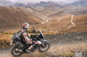 Cerro Gordo: The Ghost Town Perched 9,000 Feet Above Death Valley Perched on a windswept ridge in the Inyo Mountains, Cerro Gordo is a...
 KTM Recalls Certain 390 Adventure And Husqvarna 401 Models KTM North America has issued a safety recall affecting 9,070 motorcycles, including the...
Popular Stories

KTM 690 Rally Spotted in Near-Production Form
KTM’s “Adventure” models have become one of t...
2,500-Miles In 5 Days On A KTM 390 Adventure R. Here’s How It Went
You don’t ride long distances on the highway with...
Ducati Announces Specs & Pricing Of Street-Legal 450 Enduro Model
Ducati has officially unveiled the Desmo450 EDS...
Sena Launches Their First Dual Sport Helmet
Sena is expanding its smart‑helmet lineup again...

Notify me of new posts via email
Thanks for a great story and beautiful pics, the Owens valley is truly the gem of California!
Beautifully written and photographed! I loved this story!
Great write up. I cruised right by there in August of 2010 on my way from San Diego to Duluth via Spokane. Was 115 on the way out of the city. My 2002 fully loaded DL1000 would not have been the bike for where you guys went.
Great photos with a wonderful story Jon. I’m lucky enough to live here in Big Pine, just south of Bishop. I’ve been to Papoose Flat, Coyote Flats and through the Saline Valley on my Polaris Sportsman quad before. Your last paragraph says it all. The terrain can get serious in a hurry here in the Eastern Sierra.
Thank you for sharing great stories and pictures Jon. Thank you for inspiration.