14 Must-See Sites on a Ride Through California’s Eastern Sierra
See what's waiting to be discovered in this land of ever-changing landscapes.
9. Mono Lake

Mono Lake is one of the oldest lakes in North America – estimated to be over one million years old. The massive lake spans 60 square miles and is constantly fed with fresh water from the mountains, however the lake has no outlet. This results in a buildup of salts and minerals which render the lake two and a half times as salty and 80 times as alkaline as the Pacific Ocean. Aside from inherent cleansing properties, the highly mineral nature of the lake results in one of the most visually striking features of the area – tufa towers. Underground springs of fresh water laden with calcium well up through alkaline lake water rich in carbonates, resulting in calcium carbonate limestone. Towers begin to form around the mouths of these springs, and continue to grow underwater until the lake level drops and reveals them.


A short distance from the best viewing spots for the tufa towers is the small town of Lee Vining. Positioned at the corner of highway 395 and Tioga Pass Road, Lee Vining serves as a gateway for Mammoth, Yosemite, and Bridgeport to the north. A recommended stop for any traveler passing through this area is the Whoa Nellie Deli. Situated inside a Mobil gas station perched on a hill with views of Mono Lake, this casual gourmet establishment offers some of the best food to be had anywhere in the valley. After feeding a bike with unleaded, riders through here can feed themselves with perfectly seasoned sashimi-grade ahi, fanned on a bed of edible seaweed, among other things.
10. Bodie

Directly north of Mono lake, surrounded by little more than high desert, the remains of a boom-and-bust mining town sits in a state of arrested decay. Rather than restore the buildings, the California Park Service has chosen to simply preserve the structures of Bodie as-is. The result is a city frozen in time, offering visitors a glimpse of what life was like in this rough-and-tumble mining town. Similar to Cerro Gordo, violence was a main theme here, however in the case of Bodie it was fueled by a population that, by some accounts, grew to around 10,000 at one point.


After the discovery of gold here in 1876, Bodie sprang to life and remained a profitable mining town until the early 1900s. Like many towns of the Western frontier, the decline of Bodie came rapidly. While the population had dwindled to just 120 by 1920 according to US Federal Census data, Bodie’s post office continued operating until 1942.
11. Manzanar
Roughly halfway between Lone Pine and Independence, just west of highway 395, lies the remains of the infamous Manzanar War Relocation Center. In 1942 thousands of Japanese-Americans were transferred to this facility. Many of the original foundations remain visible, and nearly all of the original building locations are marked.


Origami remembrances, coin offerings and other recent mementos are placed throughout the Manzanar graveyard by visitors. It’s a sobering experience to realize people were interred here as recently as 1945. Some 40 years prior to the internment camp’s existence, this land was home to thousands of acres of fruit trees, thus the name “Manzanar” – “apple orchard” in Spanish.
12. Reward Mine
Leaving Manzanar, if one simply points east and rides directly across highway 395, the road changes its name to “Reward Mine”. Following this road over the abandoned Manzanar International Airport, and roughly six to seven miles through the desert towards the mountains, the path ends at a gargantuan hole bored deep into the Inyo Mountains.

Reward Mine is actually part of a complex of several mines in the area, producing gold and silver from the 1860s until operations ceased in 1959. What separates Reward Mine from the others, and makes it a draw for offroaders, is the size. Anyone on a motorcycle, or in a capable 4×4 that isn’t too lifted, can drive roughly a quarter mile into the earth.
The narrow passageway eventually brings brave souls willing to make the trek through the inky blackness to a large room, big enough to both turn around and fit multiple vehicles. Several side tunnels and passageways can be explored along the way. Pausing to shut off all light sources in the tunnel allows for a unique experience – a form of darkness and still air that feels like a cloak.
13. Alabama Hills
Lone Pine’s single traffic signal is at the intersection of highway 395 and Whitney Portal Road. This tiny town has a high percentage of hotels for its comparatively diminutive size. Several reasons for this can be suggested. One of the primary draws to the area is Mount Whitney – the highest peak in the continental United States. Driving towards the peak along Whitney Portal Road, an easily-overlook plaque mounted to a stone sits off to the right of the road at a wide dirt pullout.


“Movie Road” is a smooth, graded dirt path through the Alabama Hills area of the Owens Valley. With no communities and virtually no structures between the Alabama Hills area and Mount Whitney, one of the most grand views of this majestic peak can be found along this path. The dizzying scale of the scenery is what resulted in Movie Road gaining its name. In 1920, The Round Up was the first feature film to use this landscape as a backdrop. From the silent film era to the 1950s alone over 300 more films were shot in the Alabama Hills. To the present day, about 30 to 40 film permits are issued per year to shoot there.
14. Shepherd Hot Springs

Publishing the location of certain hot springs can be a dicey proposition, as some of the locations are closely-guarded secrets by locals who build and maintain them. Shepherd Hot Springs is not one of these locations. A short distance away from highway 395 off Benton Crossing Road, the name of the wide, graded dirt road advertises what the area holds. Off Whitmore Tubs Road lie several hot springs. Some are more difficult to find than others, with Shepherd Hot Spring being among the easiest to find and most accessible with virtually any vehicle.


Its convenient location leads to more visitors here than many other tubs in the area. Many visitors simply pop in for a quick soak before moving on. For those wanting to remain, the public land west of the spring is open to camping, although no facilities of any kind are to be found in the area.
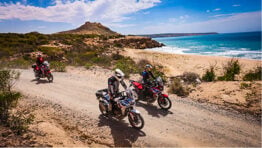
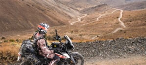
Planning Your Trip
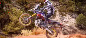
Riding Terrain: The route is roughly 65% dirt and 35% street in mileage with some long highway stretches required to connect up trails. The Eastern Sierras are a rugged area with fast elevation changes. Many of the trails are moderate but the technical difficulty level can rise quickly in bursts. You’ll need to have decent sand riding skills, especially if you are on a larger machine. Deep sand will be encountered around Olancha Dunes, Papoose Flats, Deadman Creek and the eastern side of Mono Lake. It can get technical, steep and rocky on the western approach to Cerro Gordo, climbing out of The Narrows, and heading west after Fish Slough towards the Hot Springs.

Dirt routes are accessible to large 1000cc+ adventure bikes only for those with advanced off-road skills. But even those on smaller bikes should have at least intermediate level off-road skills for the hard sections when fully loaded with gear. Some of the more technical spots can be bypassed by planning ahead and looking for alternate routes. The furthest distance between gas stops is about 175 miles. The trails never veer too far from highway 395, services are always somewhat close if you need them. It’s always a good idea to ride with friends and bring ample food, fuel, water, tools, a first aid kit, and an emergency GPS messaging device.
Weather: Summer and fall are the best times to visit the Eastern Sierras. The higher elevations are a great place to beat the heat but if you get there too early in spring or early summer, some trails may still be closed due to snow. During winter, many trails will remain open in the lower elevations around highway 395.

Elevations range from 2,500 feet to 10,700 feet (762 m to 3,261 m), so be prepared for a wide range of temperatures and wear good breathable riding gear that can handle swings in the weather and rain showers. Temperatures can soar above 115°F (46°C) during the peak of summer in the lower elevations but remain comfortable in the higher elevations. Even so, it’s a good idea to bring a warm sleeping bag for camping in the high country because nighttime temperatures can drop to freezing, even in summer.
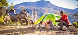
Camping/Lodging: There are many developed campsites in the Eastern Sierras, but they can get crowded and require advanced reservations. You can find a list of these on the Inyo National Forest website. But some of the best camping options are the dispersed campsites. Undeveloped sites just off the trail are plentiful. Just make sure you check local fire restrictions and get a fire permit.

If you are looking to pack light and ride hotel-to-hotel, there are many options along in the major towns along Highway 395. Lake Olancha RV park and Campground offers an excellent base from which to explore the area and the view overlooking the lake, facing the grandeur of the Eastern Sierras, is not to be missed. Motorcyclists have the option of either renting one of the five available cabins, or posting up a tent in the camping area. You can also leave a truck there for a few days for a small fee. Other areas where you can leave a truck are nearby Panamint Springs Resort or the Tractor Supply parking lot in Ridgecrest.
Gear We Used
During our expedition to the Eastern Sierras, we encountered a variety of different terrain and extreme variations in temperatures, from baking heat in the lower elevations to freezing cold when the sun dropped in the mountains. We tested several high-quality products during our journey. Here’s a list of some of the products we used on the trip that impressed us the most:
- GIVI GRT719 Hydration Pack
- Giant Loop Diablo Tank Bag
- SENA 50S Mesh Headset
- Wolfman Zip-R Rolie Bags
- REV’IT! Sand 4 Adventure Suit


You can read more about how these products performed during our expedition, on our Tumblr Page..
Maps and GPS Tracks
We’ve put together a route through Eastern Sierras that will allow you to visit all the places mentioned in this Ride Guide and more during a 6-day trip. Detailed GPX tracks and a larger interactive map are available for download free.*
* Terms of Use: Should you decide to explore a route that is published on ADV Pulse, you assume the risk of any resulting injury, loss or damage suffered as a result. The route descriptions, maps and GPS tracks provided are simply a planning resource to be used as a point of inspiration in conjunction with your own due diligence. It is your responsibility to evaluate the route accuracy as well as the current condition of trails and roads, your vehicle readiness, personal fitness and local weather when independently determining whether to use or adapt any of the information provided here.
Photos by Jon Beck, Stephen Gregory, Rob Dabney
Author: Jon Beck
Jon Beck is fulfilling a dream of never figuring out what to be when he grows up. Racing mountain bikes, competitive surfing, and touring as a musician are somehow part of what led Jon to travel through over 40 countries so far as an adventure motorcycle photographer, journalist, and guide. From precision riding for cameras in Hollywood, to refilling a fountain pen for travel stories, Jon brings a rare blend of experience to the table. While he seems happiest when lost in a desert someplace, deadlines are met most of the time.Related Stories
Related Stories
 8 Great Reasons to Ride Washington’s Olympic Peninsula 6. Scenic Backroads The Highway 101 loop around the Olympic Peninsula is considered...
 California Coast Ride: Much More To Explore Than Just Highway 1 “There’s no place like home.” Common phrase, dubious concept. Tuning into media reports,...
 Pack Smarter and Lighter for Your Next Adventure Ride How much do you need to pack for an adventure ride? Exactly what...
Popular Stories
Why I Chose A 1980's Honda Trail CT110 As My Next Adventure Bike
Well, I finally bought one. After years of eyeing...
Sena Launches Their First Dual Sport Helmet
Sena is expanding its smart‑helmet lineup again...
Honda Debuts Adventure Motorcycle Film On Streaming Platforms
Honda is bringing its flagship adventure‑tourin...
Ducati Announces Specs & Pricing Of Street-Legal 450 Enduro Model
Ducati has officially unveiled the Desmo450 EDS...
Notify me of new posts via email
Excellent write-up, photos, maps, etc.
Love these features! Keep’em coming!!
This was a phenomenal write up and story. I’ve spent a lot of time in the Eastern Sierra and reading this makes me realize how little I’ve seen.
Awesome write up! I’ve hit a few of these spots on the bike, super easy to zip to and from and hit many spots. The 395 is such a beautiful area with so much to explore.