California Coast Ride: Much More To Explore Than Just Highway 1
Sea To Sky - hitting the high notes on a ride up California’s Central Coast.

“There’s no place like home.” Common phrase, dubious concept. Tuning into media reports, apparently my home state is characterized by a list of qualities including fires, earthquakes, sky-high home prices, and gluten-free water. I’ve found the solution: Turn off the TV and go for a ride. Turns out, this place is pretty amazing.
Somewhere out there is a movie location scouting map from the silent film era depicting California divided up into various regions, which aesthetically correspond to different spots on the globe. Having traveled through over 40 countries, the diversity of this state never ceases to amaze. This elongated section of the U.S. can mimic various parts of Europe, Africa, Australia, Canada, and the list goes on. Recently, I had the opportunity to hop aboard a gorgeous Moto Guzzi V85 TT Travel and go for a spin through a place I thought I knew pretty well, but am always learning there’s more to discover in one’s own backyard.
Rolling into the ADV Pulse offices early on a Tuesday morning served to underscore the diversity of this state. Tucked into a nondescript industrial park in Torrance, we rallied in an empty parking lot under gray skies surrounded by what feels like endless miles of infrastructure. A quick fuel stop, followed by a party with 100,000 strangers isolated in separate vehicles on a 10-lane highway for a few hours, and the scene quickly flips to the exact opposite the moment we reach Santa Barbara and point the bikes up into the hills.


Dizzyingly twisty roads weave between houses which seem to simultaneously increase in beauty and thin in proximity until finally we’re on an empty road, winding through an ideal morning, to views of the Pacific Ocean and the hum of finely tuned motorcycles. Should you find yourself in this county, make Gibraltar and Camino Cielo roads a priority.

Just a few miles off Camino Cielo, the Chumash Painted Cave State Historic Park is one of those unique places that shows how easily history can become an afterthought. Fortunately preserved, the tiny site sits alongside a thin strip of asphalt winding through a small mountain community, with little more than an easily-missed sign marking its location. The beautiful and unusually colorful petroglyphs that are more than 400 years old are easy to pass by without noticing, but well worth the short stop to take in.
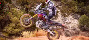
First Taste of Dirt

Adventure riders will be pleased to know that the asphalt can be avoided here and there in these mountains. West Camino Cielo road is a sometimes rocky but largely easy fireroad option which provides views of the San Rafael mountains, Chumash Lake, and the Pacific Ocean along its gradual descent towards Solvang on Refugio road, where we link up with U.S. 101. Arguably unique among its thoroughfare compatriots, the 101 is as much scenic byway as it is highway. Scenic as it may be, it’s difficult to top the Pacific Coast Highway for endless vistas, and Hollywood knows it.

Numerous movies have been filmed over the years along the California coast, some more memorable than others. Cayucos State Beach doesn’t immediately bring to mind references to “The Monster of Piedras Blancas,” but it was filmed there. Further to the north, we roll through Cambria where malevolent spiders gave people a hard time in “Arachnophobia”. A mere five miles beyond Cambria, in San Simeon, one can see both ancient Rome, and a fictional tropic nation while standing in the same spot: Laurence Olivier was hanging out at Hearst Castles’ Neptune Pool in Stanley Kubrick’s “Spartacus” 25 years before Arnold Schwarzenegger landed in a seaplane at William Randolph Hearst State Beach and destroyed Val Verde in “Commando”.
Roaring Beasts


Immediately adjacent to all this glitz and glamour, 16-foot, 5,000-pound creatures regularly hang out on a beach and ignore whatever the humans are up to. Seal Point is an oddly unique spot along this coastline where gargantuan elephant seals gather, and are able to be seen year-round. The viewing area provides a welcome break from the road, and has information signs along the short boardwalk overlooking the beach crowded with these bulbous-nosed beasts battling for mating right. Climbing back onboard the Moto Guzzi and thumbing the starter, the loud vocalizations of these submarine-size swimmers are muffled by the soothing soundtrack of the V85 TT’s exhaust note.

The tiny community of Gorda provides one of the few opportunities for fuel and supplies along Central California’s rugged coastline. Just a mile or two north of the only gas stop, Los Burros Road offers an unpaved option ascending into the hills, and winds all the way to Nacimiento-Ferguson Road. Even with its street-biased Michelin Anakee Adventure tires, the Guzzi feels perfectly suited to this somewhat rough unpaved forest road — sliding through corners fully-loaded with panniers. After passing through a small community of mountain homes and cabins towards the beginning of this route, eventually all modern infrastructure disappears, and the only evidence of development is the dirt road winding through these coastal mountains.
A Sea of Clouds

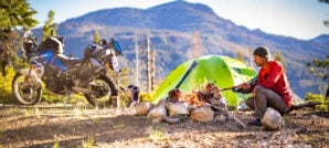
Summer in this region is well-known for “June gloom”, usually represented by an extremely thick marine layer, shrouding everything in a constant state of dreary overcast dimness. This phenomenon tends to hug the coastline and stay fairly low however, so climbing the dirt road up from Gorda quickly results in popping out into a brilliantly sunny day. Islands of land floating on an even sea of clouds are all that can be seen from the high viewpoints facing the coastline. Choosing a campsite overlooking one of these vistas offers a bizarre experience that’s probably not written up in any California tourist brochure. While the coastline is completely obscured by the clouds below, we’re only about a mile from the ocean as the crow flies. The result is mountain views and the scent of salt air mixed with pine trees, with a soundtrack of sea lions barking in the background.


Views along the unpaved Coast Ridge route are echoed by equally impressive views descending the pavement of Nacimiento-Fergusson road back towards the ocean. The curves are incessant, extremely tight, sometimes covered in sand falling from the mountains above, and nearly all have severe exposure with no guardrail. Apparently, this is exactly the type of road the V85 TT really likes. Both the ABS and traction control systems on the Moto Guzzi are put to the test on these curves, and aid in scraping pegs all the way down this road back to Highway 1. Meeting the Pacific at Kirk Creek Campground, the remoteness of the high coastal mountains is immediately replaced by crowded campgrounds and roadside viewpoints. The stretch of Pacific Coast Highway around Big Sur is no secret when it comes to scenery, and there’s typically a fair amount of folk around taking in the views.


Just south of Carmel, Bixby Bridge is one of the most photographed landmarks in California. The graceful arc was the longest bridge of its kind when completed in 1932. While there is a viewpoint parking area off PCH at the north end of the bridge where most tourists stop, unpaved Old Coast Road provides alternate vantage points of this same structure from across a large ravine as it winds all the way down to Andrew Molera State Beach.
The Return Home

After reaching our farthest point north, we eventually made our way inland over the mountains along Interlake Road — a twisty, and mostly empty, option heading southeast. Almost shockingly devoid of other vehicles, this section of road between Nacimiento-Fergusson and Highway 101 was echoed by an even greater degree of emptiness after crossing the 101 and getting on Highway 58.

Staying on Highway 58 headed east will take one directly to the northern entrance of the Carrizo Plain National Monument, however around 20 miles shy of that, veering off the asphalt and dropping south gets you to the Pozo La Panza OHV area. Arguably a lesser-known riding area, Pozo La Panza has over 40 miles of trails, ranging from beginner to expert-only level. For adventure bikes simply wanting to get off the pavement for a bit or to camp for the night, the 10-mile scenic backcountry route through the park is a pleasant detour. Eventually, the access road leads all the way back to the 58, and reconnects about 10 miles west of the Carrizo Plain National Monument.
Into The Chasm
Highway 58 is scenic in its own regard, but the history and vistas provided by the Carrizo Plain National Monument make the detour worthwhile. Remnants of abandoned farming and ranching efforts are scattered throughout the plains and valleys of this national monument, a testimony both to the land’s harsh nature, and resiliency of those who attempted to settle there. Simultaneously the most obvious, and easy to overlook feature of the Carrizo plain is the San Andreas Fault. This giant scar threatening to disunite a huge chuck of California away from the rest of the United States is most easily seen from the air. At ground level, it’s easily dismissed as just a low mountain range, even when one is riding right down the middle of the fault itself!


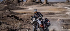
Soda Dry Lake Road provides a well-maintained path through the monument, and several sites of historic significance to check out. For those wanting a more adventurous route, heading east over the mountains to Simmler Soda Lake Road provides even more remote views, much less chance of encountering other tourists, and eventually a steep, rocky descent down Elkhorn Grade approaching Maricopa. Whether by accident of birth or intentional design of the motorcycle, the fit of Moto Guzzi for my size shines here. Arguably best suited for long road days in the saddle, the V85 TT doesn’t shy away from leaving the tarmac and getting you up on the pegs for some off-road exploration

Less than a mile from the southern entrance to Carrizo Plain National Monument, Cerro Noroeste slowly climbs southeast into the mountains towards Pine Mountain. The initial part of this road provides some of the highest quality paved curves to be found in this part of California. Little-to-no traffic, wide-open views, and (what seemed like) virtually no limits on traction, the Guzzi’s longitudinal V-twin got a thorough workout on this long stretch of pavement. The pattern of linking endless back-to-back sweepers was only broken by leaving the asphalt and jumping on a 15-mile dirt road through Quatal Canyon which led all the way back to Highway 33.
Aside from the scenic and fun nature of Cerro Noroeste road, this deviation had the added benefit of cutting out a large portion of the more straight parts of highway 33. Soon the asphalt strip begins to slightly meander along the Cuyama River, and becomes a proper sport bike road immediately after passing its intersection with Lockwood Valley road. Given the quality of this portion of the highway, and its proximity to greater Los Angeles, one can almost always expect to share it with a few others, even mid-day during the middle of the week.

Agriculture and industrial infrastructure increasingly begin to give way to suburbia the further south one gets from the Topatopa Mountains, but this doesn’t lessen the amount of fun motorcycling to be had. Even with its sometimes crowded beaches, the rugged coastline south of Point Mugu has an oddly remote feel for a place just over the hill from the second largest city in the United States. Equally unusual are the amount of high-quality roads to ride in the area between Point Mugu and Santa Monica to the south.
Canyons of Malibu

Decker Canyon is an easily-missed intersection which tees right into PCH, and immediately climbs through a series of extremely tight corners. While not necessarily “expert only”, this is not a road for beginner motorcyclists. Endless sharp corners, steep drops, and distracting views mean concentration is paramount on this road. Stopping at a pullout to take in a view, evidence of what results from a lack of concentration here can be seen in the form of wadded up vehicles wedged into the canyon floors below.
Mulholland is arguably the most famous motorcycle route in this area, and the Rock Store likely its most famous landmark. Along with typical weekend crowds comprised primarily of motorcyclists, celebrities such as Jay Leno can be seen fairly regularly here, typically riding some unique machine.


Eventually the 10 freeway, and its usual sea of slow-moving traffic jarringly reminds us that the tranquil remoteness we were riding through just a few hours ago is both right next door, and simultaneously a world away. As the hub of the entertainment industry, one aspect of Los Angeles is the creation of virtual “escapes” in the form of shows, movies, games, and other media. It used to be regular practice for people to gather around a television set to take in these escapes, but who watches TV anymore? Little screens have usurped big screens in many ways, and now we have the ability to carry a device in a pocket to constantly remind us of distressing things. For my part, it’s apparently much easier to “tune out” than ever before, as I seem to have misplaced my cell phone. I know exactly where my bike key is however. All good.

Photos by Stephen Gregory
Author: Jon Beck
Jon Beck is fulfilling a dream of never figuring out what to be when he grows up. Racing mountain bikes, competitive surfing, and touring as a musician are somehow part of what led Jon to travel through over 40 countries so far as an adventure motorcycle photographer, journalist, and guide. From precision riding for cameras in Hollywood, to refilling a fountain pen for travel stories, Jon brings a rare blend of experience to the table. While he seems happiest when lost in a desert someplace, deadlines are met most of the time.Related Stories
Related Stories
 10 Great Reasons To Ride California’s Central Coast Somewhere in Hollywood, buried under a pile of discarded relics from the silent...
 A Moto Expedition To The Fabled Lost Coast In Northern California, a four-hour drive from San Francisco, there lies a stretch...
 Carrizo Plain: One Of California’s Often Overlooked ADV Destinations Early explorers did not have it easy, compared to us in the present...
Popular Stories
Sena Launches Their First Dual Sport Helmet
Sena is expanding its smart‑helmet lineup again...
Ducati Announces Specs & Pricing Of Street-Legal 450 Enduro Model
Ducati has officially unveiled the Desmo450 EDS...
Honda Debuts Adventure Motorcycle Film On Streaming Platforms
Honda is bringing its flagship adventure‑tourin...
8 Simple Things To Make Moto Camping More Comfortable
For adventure riders, camping can be a divisive t...
Notify me of new posts via email
Nice writeup. Great photography.
Great story,beutiful pictures, I love my moto guzzi.
I did 90% of this on my solo trips. Still love it.
The writing was outstanding, the subject fascinating, and the photos beautiful!
How can I get the mapping (gpx)? Thanks,
We are currently working on a more detailed guide to riding the California Pacific Coast which will include a GPX file of the route. Stay tuned!
Did you guys ever post the gpx?
We have posted the tracks and an interactive map here: https://www.advpulse.com/adv-rides/california-central-coast-ride-guide/
OMG that backlit ‘june gloom’ mist photo looking up into the trees – it’s pure art Stephen… 😉
I live in San Luis Obispo and have ridden most of these roads and trails. But you highlighted some new ones for me – much appreciated. Also interested in GPX tracks like the other guys below.
Thanks Dave! We have posted the tracks and an interactive map here. Be sure to check out the “planning your trip” section: https://www.advpulse.com/adv-rides/california-central-coast-ride-guide/
Please forward tracks and interactive map to: w.dschlr@gmail.com. Thanks so much. Bill Deschler
Hi
hows the GPX file coming?
tracks available here! https://www.advpulse.com/adv-rides/california-central-coast-ride-guide/
Awesome! Thank you so much.